Filter: Subject of wisconsin river (wis.)
Filter: Subject of state parks and reserves
Filter: Subject of wisconsin river (wis.)
Filter: Subject of state parks and reserves
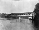
| Date: | |
|---|---|
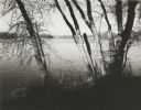
| Description: | View along right side of shoreline toward a Chicago, Minneapolis, and St. Paul train crossing a bridge over the Wisconsin River. |

| Date: | 1945 |
|---|---|
| Description: | Wyalusing State Park in the Prairie du Chein vicinity. The Wisconsin River is in the foreground and the Mississippi river can be seen below with distant bl... |
| Date: | 1950 |
|---|---|
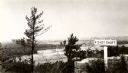
| Description: | A view from a bluff on Tower HIll overlooking the Wisconsin River. A sign on the right reads: "Shot Shaft". |
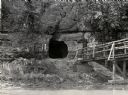
| Date: | 1950 |
|---|---|
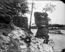
| Description: | View across river towards the tunnel leading to the bottom of the shot tower shaft at Tower Hill State Park. There is a rustic bridge on the right leading ... |
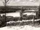
| Date: | 1945 |
|---|---|
| Description: | View from the bluff at Tower Hill State Park of the Wisconsin River. A sign on the right reads: "Tower Hill State Park Shot Shaft". |
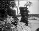
| Date: | 1910 |
|---|---|
| Description: | A winter view of Chimney Rock at the Dells. There is snow on the ground and ice on the river. |
| Date: | 1910 |
|---|---|
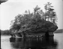
| Description: | View across Wisconsin River of men and women in canoes at the base of Lone Rock at the Dells. |
| Date: | 1909 |
|---|---|
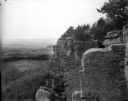
| Description: | Side view of a woman sitting on a rock ledge on the face of Gibraltar Rock bluff. Hills, fields and the Wisconsin River are visible far below in the backgr... |
| Date: | 11 11 1961 |
|---|---|
| Description: | View along the Wisconsin River, looking upstream from near Tower Hill State Park toward Highway 14 bridge. |

| Date: | 1952 |
|---|---|
| Description: | The famous Dells of the Wisconsin River. A souvenir map embellished with bits of history and points of interest. |
| Date: | |
|---|---|
| Description: | Three hunters and their dog posing on the top of Stand Rock. Text at right: "Wanderings Among the Wonders and Beauties of Wisconsin Scenery." |

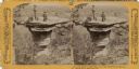
| Date: | 06 24 1878 |
|---|---|
| Description: | Stereograph of three men at the top of Stand Rock. One man is standing holding his rifle, while the two other people are sitting. Text at right: "Wandering... |

| Date: | |
|---|---|
| Description: | Stereograph of a man sitting at Devil's Elbow. Text at right: "Wanderings Among the Wonders and Beauties of Wisconsin Scenery." |

| Date: | 1920 |
|---|---|
| Description: | A map of the Nelson-Dewey State Park at the confluence of the Mississippi and Wisconsin rivers, showing the topographical features of the area, as well as ... |

| Date: | 1920 |
|---|---|
| Description: | This 1920 map actually depicts present-day Wyalusing State Park at the confluence of the Mississippi and Wisconsin rivers in the Town of Wyalusing, Grant C... |

| Date: | 1990 |
|---|---|
| Description: | This late 20th century tourist map of Sauk County, Wisconsin, shows the highways and roads, cities and towns, parks, airports, canoe landings, hospitals, s... |

| Date: | 1948 |
|---|---|
| Description: | This outline map of Sauk County, Wisconsin, shows the towns, cities and villages, railroads, and streams in the county. |

| Date: | 02 1937 |
|---|---|
| Description: | This topographical map of the forest preserve shows highways, roads, trails, telephone lines, Native American reservations, Ranger sub-stations, state nurs... |
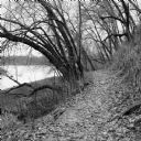
| Date: | 11 2013 |
|---|---|
| Description: | View down a small dirt path lined with grasses and trees along Ferry Bluff State Natural Area. To the left is Honey Creek leading to the Wisconsin River. |
If you didn't find the material you searched for, our Library Reference Staff can help.
Call our reference desk at 608-264-6535 or email us at: