 Filter: Subject of wisconsin river (wis.)
Filter: Subject of streets
Filter: Subject of wisconsin river (wis.)
Filter: Subject of streets

| Date: | 1879 |
|---|---|
| Description: | This map is a bird's-eye view of Wausau, the County Seat of Marathon County. The map features an index of points of interest. |
| Date: | 1928 |
|---|---|
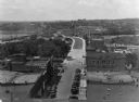
| Description: | Elevated view of the main street with the Wisconsin River in the top left corner. The street just outside the Hall Garage Company is lined with cars. |

| Date: | 1925 |
|---|---|
| Description: | Aerial view of buildings in the downtown area. |

| Date: | 1854 |
|---|---|
| Description: | This map is ink and watercolor on tracing cloth and shows lot and block numbers, streets, a park, and depots. Some lots are colored red or blue and some in... |

| Date: | 1835 |
|---|---|
| Description: | Plat for a proposed Sinsinawa City (never built), in Grant County, Wis. When it became clear in the mid-1830s that Wisconsin Territory would be established... |

| Date: | 1965 |
|---|---|
| Description: | Map shows original plat, plat additions, and lot measurements for Rothschild, Wisconsin. Lake Wausau and the Wisconsin River are labelled. Map reads: "Comp... |

| Date: | 1910 |
|---|---|
| Description: | This map of Stevens Point shows the Wisconsin River, labeled plat additions, numbered lots, and some land ownership. An inset map in the bottom left corner... |

| Date: | 1887 |
|---|---|
| Description: | This map of Tomahawk shows the Wisconsin River, numbered lots, and labeled streets. The back of the map reads: "Henry C. Payne, 424 Broadway, - - Milwaukee... |

| Date: | 1932 |
|---|---|
| Description: | This map of Wausau shows lots and landownership, buildings, roads, railroads, parks, city wards, and the Wisconsin River. The map features an inset map sho... |
| Date: | 1955 |
|---|---|
| Description: | This map of Wausau distributed by the Wausau Chamber of Commerce was originally published in July of 1940 and shows the Wisconsin River. The map includes a... |

| Date: | 1940 |
|---|---|
| Description: | This map of the Wisconsin Dells shows original plats and various additions. Some streets are labeled as is the Wisconsin River. The map was originally crea... |

| Date: | |
|---|---|
| Description: | Main house for Colburn's Modern Cottages on the Wisconsin River. A curb is in the foreground, and a dirt road leads to a garage and a cottage. An automobil... |

| Date: | 01 01 1856 |
|---|---|
| Description: | This map is mounted on cloth and shows lots, as well as location of the public square and college. Streets are labeled as is the Wisconsin River. |

| Date: | 06 1931 |
|---|---|
| Description: | This map is a photocopy of a map that has been hand-colored and shows streets, the Wisconsin River, Mill Pond, and points of interest that include a school... |

| Date: | 1920 |
|---|---|
| Description: | This street map was likely given out by the Rebholz Company: Clothiers and Furnishers. The map shows labeled streets, train tracks, Silver Lake, Mud Lake, ... |

| Date: | 1987 |
|---|---|
| Description: | This pictorial map shows roads, bridges, local businesses with phone numbers, and public buildings. Relief is shown pictorially. Also included is a calen... |

| Date: | 1838 |
|---|---|
| Description: | This map is a development plat that shows street names, numbered blocks and lots, and small farm lot owners. Included on the right of the map is a large am... |

| Date: | 1986 |
|---|---|
| Description: | Pictorial map showing businesses with phone numbers, roads, railroads, and parks. Includes text titled: "History of Portage County." |

| Date: | 11 1836 |
|---|---|
| Description: | This map is pen-and-ink on paper and is a plat of a paper city on the Wisconsin River, in what is now the Town of Dekorra. The map shows lot and block numb... |

| Date: | |
|---|---|
| Description: | This plat map shows lots and block numbers of a paper city located on the Wisconsin River and Hasting’s Creek, in what is now the Town of West Point, Colum... |
If you didn't find the material you searched for, our Library Reference Staff can help.
Call our reference desk at 608-264-6535 or email us at: