 Filter: Subject of wisconsin river (wis.)
Filter: Subject of trails
Filter: Subject of wisconsin river (wis.)
Filter: Subject of trails

| Date: | 1936 |
|---|---|
| Description: | This map is red and black ink on tracing cloth and is oriented with north to the upper left. This hand-drawn map shows a central portion of the military ro... |
| Date: | |
|---|---|
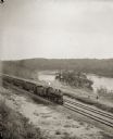
| Description: | Elevated view of a train running parallel to the river, past the Ink Stand. Several people are standing along the tracks and waving. |

| Date: | |
|---|---|
| Description: | Stereograph of elevated view of Barn Bluff. The Mississippi River is in the far background. |

| Date: | 1920 |
|---|---|
| Description: | Shows 10 land and water trails along rivers and other bodies of water in northern Wisconsin and the Upper Peninsula of Michigan; each trail numbered and de... |

| Date: | 1920 |
|---|---|
| Description: | A pedestrian path along the Wisconsin River. An advertisement for J.M. Brophy general store is painted on the rock formations along the path. |
| Date: | 1931 |
|---|---|
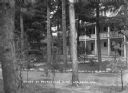
| Description: | View across stone-lined paths toward the annex, a three-story building with a porch and a balcony above. Pines trees are on the grounds, and there is a sma... |

| Date: | 1800 |
|---|---|
| Description: | This map is pencil on tracing paper and shows marshes, the Wisconsin River, Indian trails, and Indian boundary line. The upper left corner reads: "Let sect... |

| Date: | 02 1937 |
|---|---|
| Description: | This topographical map of the forest preserve shows highways, roads, trails, telephone lines, Native American reservations, Ranger sub-stations, state nurs... |

| Date: | 1829 |
|---|---|
| Description: | This map shows waterways, trails, settlements, Indian villages, and boundaries. The map includes text in the lower left with excerpts from Indian land trea... |
| Date: | 1907 |
|---|---|
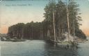
| Description: | Text on front reads: "Hog's Back, Tomahawk, Wis." The Hog's Back is a tree covered peninsula on Lake Mohawksin, also the former name of Bradley Park. A man... |
If you didn't find the material you searched for, our Library Reference Staff can help.
Call our reference desk at 608-264-6535 or email us at: