 Filter: Subject of women
Filter: Subject of exploration
Filter: Subject of women
Filter: Subject of exploration
| Date: | 1880 |
|---|---|
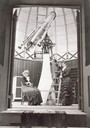
| Description: | Maria Mitchell, first woman astronomer in the United States at Vassar College. |

| Date: | 01 27 1968 |
|---|---|
| Description: | Woman working on a wire harness for the lunar module section of an Apollo spacecraft at the AC Electronics division of General Motors Corp. plant. |

| Date: | 1966 |
|---|---|
| Description: | Astronaut Alan Shepard (second from the left), then the head of NASA's astronaut office, talks with the press at Cape Canaveral before the Gemini 8. On Apr... |

| Date: | 1685 |
|---|---|
| Description: | A detailed map of the western hemisphere showing cities, settlements, Native American land, rivers, lakes, mountains, the Great Lakes, and California as an... |

| Date: | 1684 |
|---|---|
| Description: | Map of North America showing some colonies, cities, rivers, lakes, and Native American land. Ship routes spread across both oceans, including one decorated... |

| Date: | 1710 |
|---|---|
| Description: | Map of North America showing the European claims, Native American land and villages, rivers, lakes, cities, and notes on explorers, discoveries, and topogr... |

| Date: | 1766 |
|---|---|
| Description: | This map of North America shows the boundaries of European claims at the end of the French and Indian war. The British colonies extend to the Mississippi. ... |

| Date: | 1759 |
|---|---|
| Description: | Map of north eastern Canada and parts of New England, showing settlements, cities, portages, Native American land, mountains, lakes, and rivers. The unusua... |

| Date: | 1720 |
|---|---|
| Description: | Map of North America from from the Rio Grande to the Atlantic Ocean, showing boundaries, the colonies, cities, settlements, mines, forts, Native American l... |

| Date: | 1720 |
|---|---|
| Description: | Detailed, ornate, and comprehensive map of America from the east coast to present day Texas. Numerous features appear throughout the map, including Native ... |
If you didn't find the material you searched for, our Library Reference Staff can help.
Call our reference desk at 608-264-6535 or email us at: