 Filter: Year of 1700-1799
Filter: Year of 1790-1799
Filter: Year of 1700-1799
Filter: Year of 1790-1799

| Date: | 1795 |
|---|---|
| Description: | Map of the United States east of the Mississippi River. It features roads, cities, towns, early settlements, Native American land, forts, mountains, rivers... |

| Date: | 1795 |
|---|---|
| Description: | Heavily detailed and rare map of the United States. The map features the states, territories, cities, towns, forts, mines, mountains, swamps, lakes, and ri... |

| Date: | 1796 |
|---|---|
| Description: | Map of the United Sates, showing the borders between the states and territories, a few cities, mountains, portages, waterfalls, lakes, and rivers. Tennesse... |

| Date: | 1795 |
|---|---|
| Description: | Map of Maine, showing a few cities, harbors, hills, mountains, lakes, and rivers. A road runs from Pownalboro south to Portsmouth harbor, and the boundary ... |
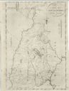
| Date: | 1791 |
|---|---|
| Description: | Detailed map of New Hampshire. It shows counties, cities, mountains, highlands, lakes, and rivers. The acres given to Dartmouth College are labeled far in ... |

| Date: | 1795 |
|---|---|
| Description: | Map of Vermont showing counties, townships, cities, roads, mountains, lakes, and rivers. A forest and waterfall scene decorates the title cartouche in the ... |

| Date: | 1795 |
|---|---|
| Description: | Map of Massachusetts showing counties, cities, roads, islands (including Nantucket and Martha's Vineyard), mountains, hills, lakes, and rivers. Two small e... |

| Date: | 1799 |
|---|---|
| Description: | Map of Rhode Island showing counties, townships, cities, roads, mountains, swamps, islands, reefs, lakes and rivers. Several of the bigger cities include s... |

| Date: | 1795 |
|---|---|
| Description: | Map of Rhode Island showing counties, townships, cities, roads, mountains, swamps, islands, reefs, lakes and rivers. Several of the bigger cities include s... |

| Date: | 1795 |
|---|---|
| Description: | Map of Connecticut showing counties, townships, cities, roads, islands, swamps, hills, mountains, lakes, rivers, reefs, and numerous other geographical and... |

| Date: | 1795 |
|---|---|
| Description: | Detailed map of New York, showing counties, cities, mines, mills, roads, swamps, mountains, lakes and rivers. The map also shows Native American towns and ... |

| Date: | 1795 |
|---|---|
| Description: | Map of New Jersey showing counties, cities, towns, mills, landowners, roads, mountains, bays, rivers, and lakes. A few annotations dot the map, describing... |

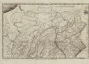
| Date: | 1792 |
|---|---|
| Description: | Map of Pennsylvania showing counties, cities, towns, forges and mills, houses, roads, portages, mountains, lakes, and rivers. The map also shows donation a... |
| Date: | 1795 |
|---|---|
| Description: | Map of Pennsylvania showing counties, cities, roads, quarries, roads, mountains, lakes and rivers. |

| Date: | 1795 |
|---|---|
| Description: | Map of Delaware showing counties, cities, roads, swamps, lakes, and rivers. Numerous features within the Delaware Bay include banks, shoals, and oyster be... |

| Date: | 1795 |
|---|---|
| Description: | Map of North Carolina showing counties, cities, towns, courthouses, forts, roads, mountains, swamps, inlets, waterfalls, lakes, and rivers. A dotted square... |

| Date: | 1795 |
|---|---|
| Description: | Map of South Carolina showing the precincts, cities, towns, Native American villages (marked with a triangle), courthouses, roads, mountains, swamps, islan... |

| Date: | 1795 |
|---|---|
| Description: | Map of Georgia, with its borders extending to the Mississippi River. It shows borders, various boundary lines, counties, cities, towns, Native American lan... |

| Date: | 1795 |
|---|---|
| Description: | Map of the new state of Tennessee. It shows borders, numerous boundary lines (particularly Native American boundaries), towns (European and Native American... |

| Date: | 1796 |
|---|---|
| Description: | Map of the new state of Tennessee. It shows borders, numerous boundary lines (particularly Native American boundaries), towns (European and Native American... |
If you didn't find the material you searched for, our Library Reference Staff can help.
Call our reference desk at 608-264-6535 or email us at: