 Filter: Year of 1700-1799
Filter: Year of 1790-1799
Filter: Year of 1794
Filter: Year of 1700-1799
Filter: Year of 1790-1799
Filter: Year of 1794
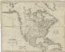
| Date: | 1794 |
|---|---|
| Description: | Map of North America showing cities, trading houses, Native American land, settlements, missions, mountains, lakes, and rivers, all in great detail. The ma... |

| Date: | 1794 |
|---|---|
| Description: | Map of the United States east of the Mississippi River. It shows borders, treaty lines, forts, cities, towns, Native American land, mountains, swamps, lake... |

| Date: | 1794 |
|---|---|
| Description: | Extremely detailed map of the south-eastern states, south from Virginia and east of the Mississippi River. It shows roads and paths, cities, towns, forts, ... |
If you didn't find the material you searched for, our Library Reference Staff can help.
Call our reference desk at 608-264-6535 or email us at: