 Filter: Year of 1800-1899
Filter: Creator Name of Lapham, Increase Allen
Filter: Year of 1850-1859
Filter: Year of 1800-1899
Filter: Creator Name of Lapham, Increase Allen
Filter: Year of 1850-1859

| Date: | 1856 |
|---|---|
| Description: | This map show the surveyed southern part of state and includes "profile of the Milwaukee and Mississippi Rail Road." Counties are shown in pink, green, blu... |

| Date: | 1852 |
|---|---|
| Description: | Map reads: "The State of Wisconsin- compiled from the latest authorities". In addition, there is a scale which is six miles for every inch, and a profile o... |

| Date: | 1855 |
|---|---|
| Description: | This map shows counties, cities, rivers, canals, lakes, railroads, common roads, county towns, townships, villages, and post offices. The map includes part... |

| Date: | 1851 |
|---|---|
| Description: | Diagram of an effigy mound in the shape of a cross. |

| Date: | 1851 |
|---|---|
| Description: | Map of a portion of Merton including the Bark River, a mill, Fort Hill, and Indian mounds. |

| Date: | 1850 |
|---|---|
| Description: | This detailed map outlines mid and southern WI county boundaries in bright color, and city/town lines are provided. Other marks include lead mines, copper ... |

| Date: | 1850 |
|---|---|
| Description: | Mid and southern Wisconsin counties, city/town lines, lead mines, copper mines, streams, plank roads, and the Milwaukee and Mississippi Rail Roads. |

| Date: | 1851 |
|---|---|
| Description: | Map outlines mid and southern Wisconsin county boundaries in blue, and city/town lines are provided. Other marks include mines, plank roads, and railroads. |

| Date: | 1853 |
|---|---|
| Description: | Railroad map outlines mid and southern Wisconsin county boundaries in red, and city/town lines are provided. Other marks include lead mines, copper mines, ... |

| Date: | 1857 |
|---|---|
| Description: | This map shows the township survey grid and identifies counties, named towns, cities and villages, rivers, lakes, and railroads. Boundaries are shown in bl... |

| Date: | 1855 |
|---|---|
| Description: | This map by Increase Lapham shows the Penokee Iron Range in Ashland and Iron counties, Wisconsin. Part of the Gogebic Range, the Penokees extend from an ar... |

| Date: | 1854 |
|---|---|
| Description: | Reproduction printed on glossy, cloth-backed paper. Right side includes "References," or points of interest that correspond to numbers on the map. Running ... |
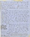
| Date: | 06 28 1850 |
|---|---|
| Description: | Letter from Increase Lapham to his wife, Ann Maria Alcott, in Milwaukee. Lapham was at Aztalan and wrote to Anna regarding the geology of the region. He in... |

| Date: | 1850 |
|---|---|
| Description: | Map showing Indian mounds and graves as well as ground cover types at Township 8, Range 22. There is an inset diagram of an effigy mound labeled "The Cross... |
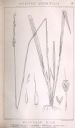
| Date: | 1854 |
|---|---|
| Description: | Increase Lapham's drawing of Oryzopsis asperifolia or Mountain Rice (Rough-Leaved Rice Grass). |
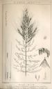
| Date: | 1854 |
|---|---|
| Description: | Increase Lapham's drawing of Zizania aquatica. The plant's common name is Northern Wild Rice. |

| Date: | 1855 |
|---|---|
| Description: | This map shows lot and block numbers, buildings, some landownership, roads, railroads, cemeteries, the Milwaukee River, and Lake Michigan. The map includes... |

| Date: | 1856 |
|---|---|
| Description: | This map shows lot and block numbers, wards, roads, railroads, and some landowner names. Lake Michigan and the Milwaukee River are labeled. Includes an ins... |

| Date: | 1857 |
|---|---|
| Description: | This map shows lot and block numbers, wards, roads, railroads, some landowners’ names, and selected buildings. The map includes an inset map of Glidden & L... |

| Date: | 1857 |
|---|---|
| Description: | This map shows lot and block numbers, wards, roads, railroads, some landowners’ names, and selected buildings. Lake Michigan, the Milwaukee River, and Glid... |
If you didn't find the material you searched for, our Library Reference Staff can help.
Call our reference desk at 608-264-6535 or email us at: