Filter: Year of 1800-1899
Filter: Subject of cities and towns
Filter: Type of Map or Atlas
Filter: Year of 1800-1899
Filter: Subject of cities and towns
Filter: Type of Map or Atlas
| Date: | 11 1899 |
|---|---|
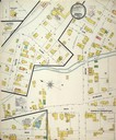
| Description: | Page 1 of Sanborn-Perris map of Pewaukee. |
| Date: | 10 1894 |
|---|---|
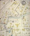
| Description: | Page 1 of Sanborn-Perris map of Pewaukee. |

| Date: | 1840 |
|---|---|
| Description: | A hand-drawn plat map of Mineral Point, Wisconsin showing street layout and location of buildings. |

| Date: | 03 30 1835 |
|---|---|
| Description: | Map of township # 7N, range no. 10 east, 4th meridian, including Third Lake. |

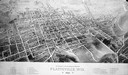
| Date: | 1892 |
|---|---|
| Description: | Bird's-eye view of the Columbian Exposition pavilions from the vantage point of Lake Michigan. Included is an inset of the Union Passenger Station (now Uni... |
| Date: | 1897 |
|---|---|
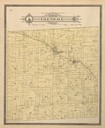
| Description: | Plat Map of Glendale Township in Monroe County. |
| Date: | 1896 |
|---|---|
| Description: | Bird's-eye map of Platteville with twenty-two locations identified below image. Town square to left of center, behind Main Street. Area bordered by Lancast... |
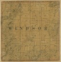
| Date: | 1861 |
|---|---|
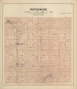
| Description: | Dane County plat map of the town of Windsor. |

| Date: | 1867 |
|---|---|
| Description: | Drawn map showing planned development of Cornell, including a couple of schools, Oakwood cemetery, the public square, and several bridges and dams. |

| Date: | 1889 |
|---|---|
| Description: | Dane County Courthouse, begun in the fall of 1883 and finished in the spring of 1886. The cost, including equipment, was a little over $180,000. |

| Date: | 1830 |
|---|---|
| Description: | Multicolor map illustrates the development of states and territories in the Old Northwest. Wisconsin was on the frontier of settlement when this map was pu... |

| Date: | 1857 |
|---|---|
| Description: | A quarter section of a map of the city of Fond du Lac. This section features an illustration of Amory Hall and the Exchange Bank of Darling & Co. |

| Date: | 1857 |
|---|---|
| Description: | A quarter section of a map of the City of Fond du Lac featuring the Empire Branch Plank Road. |

| Date: | 1857 |
|---|---|
| Description: | Quarter section of a map of the city of Fond du Lac featuring the Waupun Plank Road. |

| Date: | 1857 |
|---|---|
| Description: | Quarter section of a map of the city of Fond du Lac featuring an illustration of the Lewis House. |

| Date: | 1836 |
|---|---|
| Description: | The map of Wisconsin City on the Wisconsin River. |
If you didn't find the material you searched for, our Library Reference Staff can help.
Call our reference desk at 608-264-6535 or email us at: