 Filter: Year of 1800-1899
Filter: Subject of cities and towns
Filter: Community of Prairie du Chien
Filter: Year of 1870-1879
Filter: Year of 1800-1899
Filter: Subject of cities and towns
Filter: Community of Prairie du Chien
Filter: Year of 1870-1879

| Date: | 1870 |
|---|---|
| Description: | During the War of 1812, the only battle fought in Wisconsin was in Prairie du Chien, in 1814. Made fifty-six years later, this birds eye drawing depicts th... |
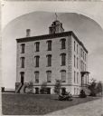
| Date: | 1872 |
|---|---|
| Description: | Alleged to be the earliest known view of St. Mary's Institute, which later became St. Mary's College. One-half of a stereograph. |
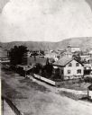
| Date: | 1870 |
|---|---|
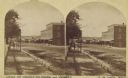
| Description: | One-half stereograph of town, elevated view looking northeast from Case's Block. |
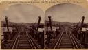
| Date: | 1873 |
|---|---|
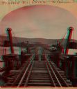
| Description: | Stereograph of John Lawler's pile-pontoon railway bridge over both channels of the Mississippi River at Prairie du Chien, and McGregor, Iowa. East draw, 39... |
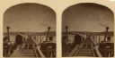
| Date: | 1870 |
|---|---|
| Description: | Stereograph of John Lawler's pile-pontoon railway bridge over the Mississippi River. Three men are standing and sitting on the bridge in the foreground. Bu... |
| Date: | 1876 |
|---|---|
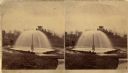
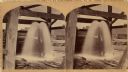
| Description: | Stereograph of artesian well, located near the intersection of Wisconsin Street and South Minnesota Street (since renamed Wacouta). |
| Date: | 1875 |
|---|---|
| Description: | Stereograph of artesian well, apparently not the same one that was located near the intersection of Wisconsin Street and South Minnesota Street (since rena... |
| Date: | 1870 |
|---|---|
| Description: | Stereograph of John Lawler's pile-pontoon railway bridge over the Mississippi River. |
| Date: | 1875 |
|---|---|
| Description: | Stereograph view of Black Hawk Avenue. |
If you didn't find the material you searched for, our Library Reference Staff can help.
Call our reference desk at 608-264-6535 or email us at:
