 Filter: Year of 1800-1899
Filter: Subject of cities and towns
Filter: Subject of architecture
Filter: Year of 1800-1899
Filter: Subject of cities and towns
Filter: Subject of architecture

| Date: | 1852 |
|---|---|
| Description: | Pencil drawing of Madison landscape as seen from University Hill. The main street in the center is State Street, and the building with Greek columns in the... |
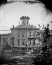
| Date: | 1877 |
|---|---|
| Description: | This building, on an entire block of Spaight and Brearly Streets with Lake Monona, was originally the governor's mansion for Leonard J. Farwell. The Farwel... |
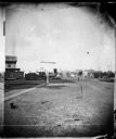
| Date: | 1873 |
|---|---|
| Description: | Locomotive, with view east on West Washington Avenue toward the Wisconsin State Capitol. There is a sign near the tracks that reads: "Look Out for The Cars... |
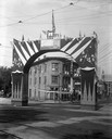
| Date: | 1898 |
|---|---|
| Description: | Wisconsin Semi-Centennial ceremonial archway erected at State and Mifflin Streets to celebrate Admiral George Dewey's victory over the Spanish fleet at Man... |
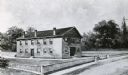
| Date: | 1848 |
|---|---|
| Description: | Sketch of the Madison Women's Seminary on the corner of Wisconsin Avenue and East Johnson. The Madison Female Academy was a 19th century school for girls w... |
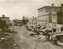
| Date: | 1859 |
|---|---|
| Description: | Daguerreotype of elevated view of Pinckney Street, looking northwest. View includes the American House and Bruen's Block, both on the corner of East Washin... |

| Date: | 1889 |
|---|---|
| Description: | Illustration of the exterior of the Fuller Opera House, which is a detail from a bird's-eye view map of Madison. |
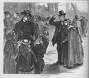
| Date: | 07 09 1870 |
|---|---|
| Description: | Irish people on the way to mass, including children surrounding the priest. |

| Date: | 1882 |
|---|---|
| Description: | Bird's-eye views of various sections of Milwaukee. |

| Date: | 1898 |
|---|---|
| Description: | Bird's-eye map of Milwaukee with prominent streets and buildings identified. Taken from City Hall Tower. |

| Date: | 1850 |
|---|---|
| Description: | Bird's-eye view of business district of Oshkosh, "drawn after nature" by the artist. |

| Date: | 1868 |
|---|---|
| Description: | Bird's-eye map of Portage, with insets of the Court House and the Public School. |

| Date: | 1870 |
|---|---|
| Description: | Bird's-eye map of Prairie du Sac. |

| Date: | 1886 |
|---|---|
| Description: | Bird's-eye map of Menomonee Falls. |

| Date: | 1870 |
|---|---|
| Description: | Sauk City is the oldest incorporated village in Wisconsin (incorporated in 1854) and also has the oldest organized volunteer fire department in the state, ... |

| Date: | 1883 |
|---|---|
| Description: | Bird's-eye map of Superior, county seat of Douglas County, on the shores of Lake Superior, with insets of points of interest. |

| Date: | 1880 |
|---|---|
| Description: | Bird's-eye map of Waukesha, county seat of Waukesha County. |

| Date: | 1885 |
|---|---|
| Description: | Bird's-eye map of Waupun on the Rock River. There is an inset at top center of "Althouse, Wheeler & Co., Windmills and Pumps." |

| Date: | 1875 |
|---|---|
| Description: | Bird's-eye map of Black River Falls, looking southwest. |
If you didn't find the material you searched for, our Library Reference Staff can help.
Call our reference desk at 608-264-6535 or email us at:
