Filter: Year of 1800-1899
Filter: Subject of cities and towns
Filter: Year of 1850-1859
Filter: Year of 1800-1899
Filter: Subject of cities and towns
Filter: Year of 1850-1859

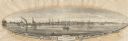
| Date: | 1854 |
|---|---|
| Description: | Bird's-eye illustration of Milwaukee. |

| Date: | 1852 |
|---|---|
| Description: | Map reads: "The State of Wisconsin- compiled from the latest authorities". In addition, there is a scale which is six miles for every inch, and a profile o... |

| Date: | 1855 |
|---|---|
| Description: | Map reads "Our Country" which is accompanied by a sailor with a flag to the left and workers rejoicing under the Constitution and Laws to the right. Across... |

| Date: | 1854 |
|---|---|
| Description: | Map reads, "Map of Wisconsin". The map includes the counties, an inset of the city of Milwaukee, total population of each county and of the state. The scal... |

| Date: | 1851 |
|---|---|
| Description: | Map of the Lake Superior region showing the railroad and steamboat connection. |

| Date: | 1858 |
|---|---|
| Description: | Map of the Lake Superior region showing the railroad and steamboat connections. |
| Date: | 1856 |
|---|---|
| Description: | Map of a portion of Douglas and La Pointe counties situated on Lake Superior. |

| Date: | 1857 |
|---|---|
| Description: | A color-coded map of the Lake Superior region, including portions of Wisconsin, Minnesota and Michigan. |
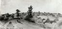
| Date: | 1850 |
|---|---|
| Description: | A watercolor painting depicting a distant view of the city of Madison, circa 1850-1851. |
| Date: | 1855 |
|---|---|
| Description: | View of Detroit with several boats and ships in (probably) the Detroit River. |
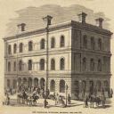
| Date: | 1855 |
|---|---|
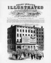
| Description: | Clipping from a newspaper or magazine. Building on a corner with a Post Office sign on left side of building, Custom House sign on the right side. Horse-... |
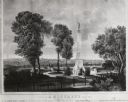
| Date: | 1855 |
|---|---|
| Description: | Lithograph showing the projected plan for the memorial. Monument is on top of a hill, looking out over the city, with a fenced off park area. Seven people ... |
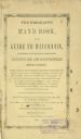
| Date: | 1851 |
|---|---|
| Description: | First page of the Hand Book to Wisconsin. |
| Date: | 1854 |
|---|---|
| Description: | A horse-drawn carriage is crossing the bridge. Right of center is the S. Ball's Candy Store. |

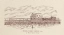
| Date: | 1856 |
|---|---|
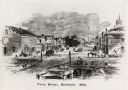
| Description: | View along bridge of paddle boats and ships in the harbor, pedestrians, and the town in the background on the other side of the river. |
| Date: | 1856 |
|---|---|
| Description: | View from bridge on river. Storefronts and homes line the road that stretches to the horizon. |
| Date: | 11 08 1856 |
|---|---|
| Description: | Political drawing for the Democratic Presidential Campaign, which included Buchanan and Breckenridge. |
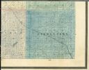
| Date: | 1859 |
|---|---|
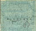
| Description: | Detail of section 5 of the Washington County map showing only Hartford. |
| Date: | 1854 |
|---|---|
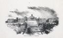
| Description: | View up Bascom Hill on the University of Wisconsin-Madison campus. |
If you didn't find the material you searched for, our Library Reference Staff can help.
Call our reference desk at 608-264-6535 or email us at: