Filter: Year of 1800-1899
Filter: Subject of cities and towns
Filter: Year of 1850-1859
Filter: Year of 1800-1899
Filter: Subject of cities and towns
Filter: Year of 1850-1859
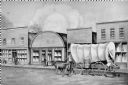
| Date: | 1858 |
|---|---|
| Description: | View on North Water Street, showing the building in which the Bank of Sparta was founded. A man is walking beside a oxen pulling a covered wagon. |

| Date: | 1855 |
|---|---|
| Description: | Map of Madison and surrounding communities, referred to as the four lakes country. Text bordering the map includes an excerpt of a letter written by Horace... |

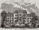
| Date: | 1859 |
|---|---|
| Description: | A drawing of the private Haskell University that was operating during the 1850's. The drawing was done by a student, Mrs. L. Campbell who spelled the name ... |

| Date: | 1858 |
|---|---|
| Description: | Pencil sketch of the Jacob Miller home. |

| Date: | 1859 |
|---|---|
| Description: | Map featuring various views of buildings and scenes from Sauk County. |
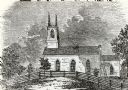
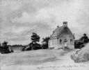
| Date: | 1854 |
|---|---|
| Description: | Exterior view of a First Congregational Church. |
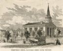
| Date: | 1858 |
|---|---|
| Description: | View of a Presbyterian church with a horse-drawn vehicle and multiple pedestrians in the foreground. Caption reads: "Presbyterian Church, Barnstable Street... |
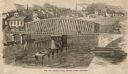
| Date: | 1858 |
|---|---|
| Description: | Elevated view of the Fourth Street bridge with various buildings in the background. Caption reads: "The New Fourth Street Bridge, Racine, Wisconsin." |

| Date: | 1859 |
|---|---|
| Description: | This 1859 railroad map shows counties, cities, rivers and lakes in the entire state of Wisconsin. It includes an inset depicting the railroads in Milwaukee... |
| Date: | 1850 |
|---|---|
| Description: | Buildings along Wisconsin River. |
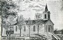
| Date: | 1851 |
|---|---|
| Description: | School and church, from a drawing by Johann B. Wengler, an Austrian traveller in this country. |
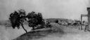
| Date: | 1850 |
|---|---|
| Description: | Body of water body in foreground with boaters, buildings on shore in background. |

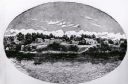
| Date: | 1850 |
|---|---|
| Description: | [... through northern United States from New York to Minnesota]. Lithography by T. Sinclair. From Perrault papers, Lucien S. Hanks, donor. |
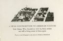
| Date: | 1850 |
|---|---|
| Description: | New Glarus from an early lithograph. Caption reads: "A Swiss contribution to American culture, New Glarus, Wis., founded in 1845 by Swiss settlers and stil... |

| Date: | 1853 |
|---|---|
| Description: | Shows railroads, planned and in place. |

| Date: | 1855 |
|---|---|
| Description: | Fox-Wisconsin portage and canal map, when the canal was not yet built. From a map in the office of the city clerk at Portage. "The old trail, the location ... |
If you didn't find the material you searched for, our Library Reference Staff can help.
Call our reference desk at 608-264-6535 or email us at: