 Filter: Year of 1800-1899
Filter: Subject of cities and towns
Filter: Year of 1860-1869
Filter: Year of 1800-1899
Filter: Subject of cities and towns
Filter: Year of 1860-1869

| Date: | 1865 |
|---|---|
| Description: | Exterior view of the Gates Gallery, location for the first H.H. Bennett studio. |

| Date: | 1868 |
|---|---|
| Description: | Showing the counties, towns and railroads. Partly colored. Scale: 1 inch = 20 miles. |

| Date: | 12 26 1862 |
|---|---|
| Description: | Handsketched map of the area around Knobs Gap. |
| Date: | 1860 |
|---|---|
| Description: | View from field of Villa Louis, the residence of Hercules L. Dousman. |

| Date: | 1862 |
|---|---|
| Description: | Lithography of C. Van Benthuysen. |
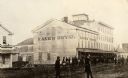
| Date: | 1865 |
|---|---|
| Description: | Kane's Hotel, built in about 1839 by Ezekiel Tainter, and then called the Phoenix Hotel, on Main Street. It passed through many hands but retained the orig... |
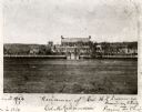
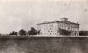
| Date: | 1864 |
|---|---|
| Description: | Oval-framed view of Lawler Hall at Campion College. This image was made during the Civil War when the building was used as a U.S. Military hospital. Prior ... |
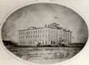
| Date: | 1865 |
|---|---|
| Description: | View across open grounds towards the Brisbois Hotel, built in the early 1860's, and used as a hospital during the Civil War. It was later part of Campion H... |
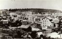
| Date: | 1868 |
|---|---|
| Description: | A view taken from the elevation on the south side of the Mullet River. |
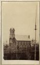
| Date: | 1864 |
|---|---|
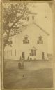
| Description: | Slightly elevated view across grounds towards the Trinity Episcopal Church, built in 1864. |
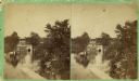
| Date: | 1860 |
|---|---|
| Description: | Stereograph of the Townsend House boathouse across a lake. |
| Date: | 1860 |
|---|---|
| Description: | Stereograph of Townsend House. Image includes people sitting on porch, grounds, boat dock. |
| Date: | 1860 |
|---|---|
| Description: | The first high school erected in Palmyra, built about 1860. People are standing in the yard. |

| Date: | 1868 |
|---|---|
| Description: | The Philteus Sawyer residence located on the northwest corner of Algoma and West Algoma Streets. Sawyer was mayor of Oshkosh from 1863-1864, and became a U... |

| Date: | 1863 |
|---|---|
| Description: | View across street towards Senator Philetus Sawyer's residence. Sawyer was elected to the U.S. Senate in 1881. People are posing in horse-drawn vehicles in... |
| Date: | 1860 |
|---|---|
| Description: | Ansicht Von St Nanianz, gregundet vom Jahr 1854 bis 1860. Sr. Hochw. Hern V. Oschald. n.p., n.d. |

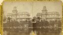
| Date: | 1868 |
|---|---|
| Description: | Stereograph of an elevated view of the Vilas House hotel, East Main Street at Monona Avenue. |

| Date: | 1862 |
|---|---|
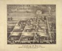
| Description: | Birds-eye view of a Wisconsin Civil War regiment on parade in Fond du Lac, as drawn by Louis Kurz from the Marr Street Methodist Church. The regiment canno... |
| Date: | 10 24 1863 |
|---|---|
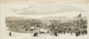
| Description: | Panoramic wood-engraving of a cattle fair in New Haven, after a sketch by H.C. Curtis. Caption reads: "Cattle Show and Agricultural Faib [sic] at Ha... |

| Date: | 1864 |
|---|---|
| Description: | Map reads: "Johnson's Wisconsin and Michigan". There is a decorative border, a scale of which ten miles is approximately one inch and individual counties d... |
If you didn't find the material you searched for, our Library Reference Staff can help.
Call our reference desk at 608-264-6535 or email us at: