 Filter: Year of 1800-1899
Filter: Subject of cities and towns
Filter: Year of 1800-1899
Filter: Subject of cities and towns
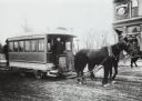
| Date: | 1890 |
|---|---|
| Description: | Man driving a horse-drawn trolley of the Milwaukee City Railroad Company on the Greenfield Avenue & Third Street line. The corner of a building advertising... |
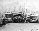
| Date: | 1886 |
|---|---|
| Description: | First electric street railway service in Wisconsin. |
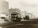
| Date: | 1890 |
|---|---|
| Description: | A large group of people posing with "Old Oshkosh," a horse-drawn streetcar, and "New Oshkosh," an electric trolley. |

| Date: | 1891 |
|---|---|
| Description: | Bird's-eye map of Wausau, looking north with ninety-eight businesses, industries, churches, schools, and civic buildings identified in location key below i... |

| Date: | 03 1892 |
|---|---|
| Description: | Detail map including West Washington Avenue, West Main Street, West Wilson Street, and North and South Bedford Streets. Includes the Chicago, Milwaukee & S... |
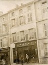
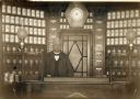
| Date: | 1889 |
|---|---|
| Description: | View of the exterior of the Pharmacie Werner in Boulay/Bolchen, France. This region was part of Germany in 1889. Two men are standing in front of the build... |
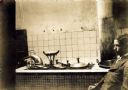
| Date: | 1889 |
|---|---|
| Description: | View of pharmaceutical processing equipment in the Pharmacie Werner. The pharmacy was located in Boulay, France. |
| Date: | 1889 |
|---|---|
| Description: | A pharmacist is standing behind the sales counter at the Pharmacie Werner in Boulay, France. At the time, Boulay was part of Germany. |
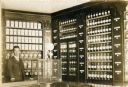
| Date: | 1888 |
|---|---|
| Description: | A view of part of the interior of the Pharmacie Werner in Boulay, France. This region was part of Germany when this photograph was taken. |
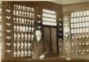
| Date: | 1889 |
|---|---|
| Description: | A pharmacist is standing in front of a case of labeled medical ingredients in the Pharmacie Werner in Boulay, France. This region was part of Germany when ... |

| Date: | 1886 |
|---|---|
| Description: | Bird's-eye view of Bayfield, county seat of Bayfield County. On the lower left side is an inset for Bayfield and the Apostle Islands. |

| Date: | 1853 |
|---|---|
| Description: | Bird's-eye map of Milwaukee looking east toward Lake Michigan from a bluff, long since graded into a slope, at about 6th Street between Wisconsin Avenue an... |

| Date: | 1885 |
|---|---|
| Description: | Bird's-eye view of Watertown with indexed points of interest. |

| Date: | 1862 |
|---|---|
| Description: | Drawn the second year of the Civil War, this 1862 map of Milwaukee shows post offices, light houses, beacon lights, county buildings, elevator warehouses, ... |
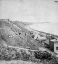
| Date: | 1877 |
|---|---|
| Description: | View of bluffs and buildings on the shore of Lake Michigan. |
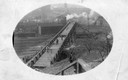
| Date: | 1895 |
|---|---|
| Description: | Men walking across a bridge over railroad tracks. |

| Date: | 1855 |
|---|---|
| Description: | Detail from a lithograph vignette on a Map of the City of Madison of the third Wisconsin State Capitol, the first Capitol in Madison. |
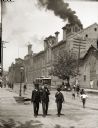
| Date: | 1888 |
|---|---|
| Description: | Exterior of Schlitz Brewing Company with two men and a boy in suits and hats in the foreground. |
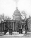
| Date: | 1899 |
|---|---|
| Description: | Third Wisconsin State Capitol (the second in Madison), showing the East Washington Avenue gateway and iron fence. In reality the statues, which were meant ... |
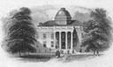
| Date: | 10 17 1853 |
|---|---|
| Description: | An engraving of the second Wisconsin State Capitol (the first built in Madison) that appeared on the notes of the State Bank of Madison, the first bank org... |
If you didn't find the material you searched for, our Library Reference Staff can help.
Call our reference desk at 608-264-6535 or email us at: