 Filter: Year of 1800-1899
Filter: Subject of human settlements
Filter: Year of 1800-1899
Filter: Subject of human settlements

| Date: | 1850 |
|---|---|
| Description: | Painting depicting Chippewa Falls and the first sawmill on the Chippewa River, built by Jean Brunet. The residence of H.S. Allen, one of the owners of the... |
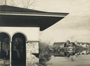
| Date: | 04 24 1899 |
|---|---|
| Description: | Partial view of a boathouse at the foot of North Carroll Street, designed by Frank Lloyd Wright and built for the city of Madison. The University of Wiscon... |
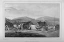
| Date: | 1850 |
|---|---|
| Description: | View of Michipicoton, Ontario on Lake Superior showing a village with log structures and tents. Fishing nets are drying on poles. |
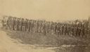
| Date: | 1862 |
|---|---|
| Description: | Company I, 7th Regiment Wisconsin Volunteer Infantry, at Upton's Hill near Germantown, Virginia. The 7th was one of three Wisconsin regiments that was part... |

| Date: | 1851 |
|---|---|
| Description: | Plat map of the Town of Madison (Township 7N, Range 9E), from Volume 4, Federal Survey Plat Books. |

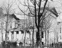
| Date: | 11 1883 |
|---|---|
| Description: | The ruins of the unfinished South Wing of the third Wisconsin State Capitol after its collapse while still under construction. |
| Date: | 11 1883 |
|---|---|
| Description: | View of the third Wisconsin State Capitol showing the ruins of the South Wing addition after it collapsed during construction. |
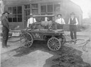
| Date: | 1887 |
|---|---|
| Description: | Peter Selb, Ben Dietrich, J.A. Lockwood, Matt Dietrich, and John Downing pose around the hand engine of the volunteer fire department. All but Selb were ch... |

| Date: | 1873 |
|---|---|
| Description: | Map of the township of Windsor, from the "Atlas of Dane County." |

| Date: | 1848 |
|---|---|
| Description: | In 1849, northern Wisconsin was composed of huge sectional regions such as Chippewa, Portage, Brown and Crawford, whereas southern Wisconsin was constitute... |

| Date: | 1873 |
|---|---|
| Description: | Newspaper reproduction of an etching of the Milwaukee River. |
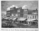
| Date: | 1844 |
|---|---|
| Description: | Illustration of the west side of East Water Street. |

| Date: | 1888 |
|---|---|
| Description: | Charles Pfeifer stands on the entrance steps to the drugstore with his wife Emma Pfeifer, who holds a baby. Other children and adults pose with them. |
| Date: | 1888 |
|---|---|
| Description: | Exterior view of Charles Pfeifer's Drugstore, founded in 1858. From left to right are Charles Pfeifer, Fred Pfeifer, Mrs. Adam Heeb, Fulda Pfeifer, Mrs. Ch... |
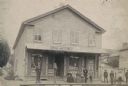
| Date: | 1890 |
|---|---|
| Description: | Customers gathered outside the J. Cunradi Drugstore. A sign above the awning identifies the store as a Deutsche Apotheke, or German apothecary. |
| Date: | 1888 |
|---|---|
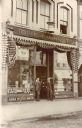
| Description: | Three men stand under the iconic mortar and pestle and striped awnings of E.A. Horn's Drugstore. |
| Date: | 1890 |
|---|---|
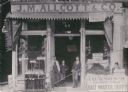
| Description: | Exterior of the drugstore of Joseph Mabbett Alcott at 90 Wisconsin Street. Pictured are Charles Alcott (left), his son, and store helpers. |
If you didn't find the material you searched for, our Library Reference Staff can help.
Call our reference desk at 608-264-6535 or email us at:


