 Filter: State of Virginia
Filter: Subject of rivers
Filter: State of Virginia
Filter: Subject of rivers

| Date: | 1744 |
|---|---|
| Description: | A map of a plan of 16,500 acres of land. |

| Date: | 02 21 1874 |
|---|---|
| Description: | African American boatmen run a rapids in a small river boat. |

| Date: | 06 1862 |
|---|---|
| Description: | The 7th Wisconsin Volunteer Infantry Regiment camp outside of Fredericksburg on the east side of the Rappahannock. Fredericksburg and a pontoon bridge lea... |
| Date: | |
|---|---|
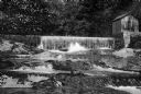
| Description: | View looking up toward a water works, a dam, and natural falls on the Jackson River with woods in the background. |
| Date: | |
|---|---|
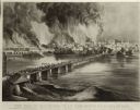
| Description: | Currier & Ives lithograph of the fall of Richmond, April 2, 1865. |
| Date: | |
|---|---|
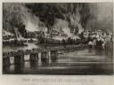
| Description: | "The Evacuation of Richmond Virginia. By the Government of the Southern Confederacy on the Night of April 2nd 1865." Before evacuating, the Confederates se... |
| Date: | |
|---|---|
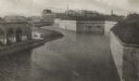
| Description: | The old fortifications at Fort Monroe, built to defend Hampton Roads and the mouth of the James River. Jefferson Davis was imprisoned here from 1865 to 186... |

| Date: | |
|---|---|
| Description: | A hand-drawn map of Indian boundary lines in southwest Virginia. It also includes the Duck River and the Elk River. |

| Date: | |
|---|---|
| Description: | Elevated view of a road and river winding through a mountainous landscape, seen from Waterlick White Hotel. Caption reads: "View from Hotel, Waterlick whit... |

| Date: | |
|---|---|
| Description: | View down hill toward the York River with small homes on its banks. Long piers stretch into the river. |

| Date: | |
|---|---|
| Description: | View across water toward a stone bridge with two arches, built in the late nineteenth century, in the wooded setting of Bull Run Battlefield. |

| Date: | 1957 |
|---|---|
| Description: | U.S.S. Wisconsin docked on the Hudson River at Norfolk, during decommissioning ceremonies. |

| Date: | 1863 |
|---|---|
| Description: | This map shows roads, railroads, settlements, farms with owners' names, vegetation, streams, and fords in Culpeper County region during the Civil War. A ma... |

| Date: | 1862 |
|---|---|
| Description: | The second in a series of three maps of the Virginia Peninsula. This map details the area from Williamsburg north to West Point. |

| Date: | 1862 |
|---|---|
| Description: | The third in a series of three maps of the Virginia Peninsula. This map details the area from Harrison's Landing west to Richmond and shows troop positions... |

| Date: | 1864 |
|---|---|
| Description: | This map of the battlefield on the North Anna River at Hanover Junction illustrates the Union positions in blue and Confederate positions in red. Roads, ra... |

| Date: | 1950 |
|---|---|
| Description: | Front view of George Washington's Mount Vernon from the circular driveway. A line of people are waiting at the entrance. The cupola on the roof has a weath... |

| Date: | 1862 |
|---|---|
| Description: | This map shows the plan of the siege of Yorktown and the Battle of Williamsburg. The map also shows fortifications, towns, roads, houses, names of resident... |

| Date: | 1865 |
|---|---|
| Description: | This map shows U.S. cavalry positions in yellow, Confederate infantry positions in blue, and Confederate cavalry positions in red. The map also shows roads... |
If you didn't find the material you searched for, our Library Reference Staff can help.
Call our reference desk at 608-264-6535 or email us at:
