 Search: Automobiles
Filter: Categories of Wisconsin Historical Images
Filter: Subject of human settlements
Filter: Subject of ferries
Search: Automobiles
Filter: Categories of Wisconsin Historical Images
Filter: Subject of human settlements
Filter: Subject of ferries
| Date: | |
|---|---|
| Description: | View of an automobile ferry boat traveling to or from Shelter Island Heights. Several men are on the ferry, along with three automobiles. "Shelter Island O... |
| Date: | |
|---|---|
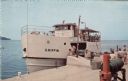
| Description: | Color postcard of a Washington Island ferry docked at Gills Rock, with an automobile in the hold and tourists on board. |

| Date: | |
|---|---|
| Description: | Four views of the S.S. Badger: the upper passenger deck, the captain at the helm, the car hold, and the ship itself. |

| Date: | 12 17 1957 |
|---|---|
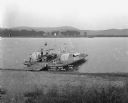
| Description: | Carferry slip with pilings in the foreground, and a shoreline in the background. The pier is made of timbers. In the background on the left is a factory wi... |
| Date: | |
|---|---|
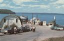
| Description: | View down road towards the ferry dock at Gills Rock. A ferry is unloading cars. A line of cars and a group of people are waiting to get on the ferry. |
| Date: | 1921 |
|---|---|
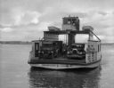
| Description: | View from shoreline looking down at three men posing on a paddle steamer ferry boat carrying an automobile. The boat has the words "Cassville" and "Dewey" ... |

| Date: | 1928 |
|---|---|
| Description: | This map shows the entire state of Wisconsin as well as portions of Michigan, Minnesota, Iowa and Illinois. Lake Michigan, Lake Superior, Lake Winnebago a... |

| Date: | 1936 |
|---|---|
| Description: | This colored road map shows automobile roads in Wisconsin as well as portions of nearby states. U.S. numbered highways are shown in red, and information ab... |

| Date: | 1936 |
|---|---|
| Description: | This colored road map shows automobile roads in Wisconsin as well as portions of Michigan, Iowa, Minnesota, and Illinois. U.S. numbered highways are shown ... |

| Date: | 1946 |
|---|---|
| Description: | This colored road map shows automobile roads in Wisconsin as well as portions of nearby states. Information on the quality and type of any road shown (Inte... |

| Date: | 1937 |
|---|---|
| Description: | This blue-line map of Wisconsin shows two maps of Wisconsin and the surrounding area, with a railroad map on one side and a road map on the other. The rail... |

| Date: | 1938 |
|---|---|
| Description: | This colored road map shows automobile roads in Wisconsin as well as portions of nearby states. Along the bottom edge of the front page, smaller road maps ... |

| Date: | |
|---|---|
| Description: | This colored road map shows automobile roads in Wisconsin as well as portions of nearby states. Information on the quality and type of any road shown (pave... |

| Date: | 1934 |
|---|---|
| Description: | This road map contains automobile routes for the state of Wisconsin as well as portions of Minnesota, Illinois, Iowa and Michigan. Lake Michigan, Lake Sup... |
If you didn't find the material you searched for, our Library Reference Staff can help.
Call our reference desk at 608-264-6535 or email us at: