 Search: Automobiles
Filter: Categories of Wisconsin Historical Images
Filter: Subject of human settlements
Filter: Subject of mississippi river
Search: Automobiles
Filter: Categories of Wisconsin Historical Images
Filter: Subject of human settlements
Filter: Subject of mississippi river
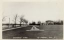
| Date: | |
|---|---|
| Description: | View of the cannon at Riverside Park. Automobiles are parked by the river on the left. Caption reads: "Riverside Park, La Crosse, Wis." |
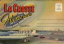
| Date: | 1938 |
|---|---|
| Description: | Front of picture envelope mailer. Inside are nine, double-sided postcards attached to the envelope. |

| Date: | 1929 |
|---|---|
| Description: | View down high bridge of two passenger cars passing one another while crossing over the Mississippi River. |
| Date: | |
|---|---|
| Description: | Aerial view of the Holiday Inn, between La Crosse on Barron Island in the beautiful Mississippi. A curved road is leading to a bridge across the Mississipp... |

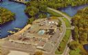
| Date: | 1932 |
|---|---|
| Description: | This map includes a distance table, text, and insets maps of, Superior, Ashland, Marinette, Green Bay, Appleton, Manitowoc, Oshkosh, Fond Du Lac, Janesvill... |
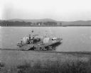
| Date: | 1921 |
|---|---|
| Description: | View from shoreline looking down at three men posing on a paddle steamer ferry boat carrying an automobile. The boat has the words "Cassville" and "Dewey" ... |

| Date: | 1924 |
|---|---|
| Description: | This map shows railroads, electric lines, and steamship lines. The left margin includes an index of principal cities, and the lower left corner includes a... |

| Date: | 1920 |
|---|---|
| Description: | This map shows the entire state as well as portions of Iowa, Illinois, Minnesota, and Michigan. Counties outlined in yellow, cities, rivers, lakes, and rai... |

| Date: | |
|---|---|
| Description: | Aerial view of brewery, with the Mississippi River in the background. Text on reverse reads: "Aerial view of G. Heilman Brewing Co., Inc., La Crosse, Wisc.... |

| Date: | 1928 |
|---|---|
| Description: | This map shows the entire state of Wisconsin as well as portions of Michigan, Minnesota, Iowa and Illinois. Lake Michigan, Lake Superior, Lake Winnebago a... |

| Date: | 1934 |
|---|---|
| Description: | This map provides automobile routes through Wisconsin along with portions of Illinois, Iowa, Minnesota and Michigan. Lake Superior, Lake Michigan, Green B... |

| Date: | 1933 |
|---|---|
| Description: | This road map shows automobile routes across Wisconsin as well as portions of Illinois, Minnesota, Iowa and Michigan. Lakes Michigan, Superior and Winnebag... |

| Date: | 1933 |
|---|---|
| Description: | This map contains automobile routes across Wisconsin and portions of Illinois, Iowa, Minnesota and Michigan as well. The state borders are clearly defined... |

| Date: | 1932 |
|---|---|
| Description: | This map shows automobile routes across Wisconsin and parts of Illinois, Michigan, Minnesota and Iowa. The Mississippi River, Lake Michigan, Lake Superior,... |

| Date: | 1934 |
|---|---|
| Description: | This road map contains automobile routes for the state of Wisconsin as well as portions of Minnesota, Illinois, Iowa and Michigan. Lake Michigan, Lake Sup... |
If you didn't find the material you searched for, our Library Reference Staff can help.
Call our reference desk at 608-264-6535 or email us at: