Search: Conservation
Search: Department
Search: Conservation
Search: Department

| Date: | |
|---|---|
| Description: | A man in a plaid jacket is feeding a bottle of milk to a fawn. |

| Date: | 1952 |
|---|---|
| Description: | This Wisconsin Conservation Dept. map shows sections, roads, rivers, and lakes in the Town of Presque Isle, Vilas County, Wisconsin as of March 1953. It do... |
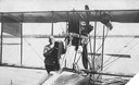
| Date: | 1915 |
|---|---|
| Description: | Jack Vilas (seated) in the Curtiss hydroplane he used to spot forest fires for the Wisconsin Conservation Department. (His companion is not identified.) Th... |
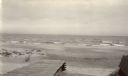
| Date: | |
|---|---|
| Description: | Beach at Terry Andrae State Park. There is a wooden boardwalk in the foreground. |

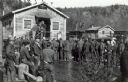
| Date: | 1936 |
|---|---|
| Description: | View across street towards men and women standing in small groups outside the brick Forest Protection Headquarters building of the Wisconsin Conservation D... |
| Date: | 07 1936 |
|---|---|
| Description: | Checking station at the entrance of Chequamegon National Forest in Taylor County. |
| Date: | 1936 |
|---|---|
| Description: | Elevated view of logs tugged across Lake Superior to the harbor at Ashland. |
| Date: | |
|---|---|
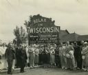
| Description: | Group of resort and hotel owners gathered in front of a Wisconsin tourism sign that reads: "Relax In Wisconsin." There is a building in the background. |

| Date: | 09 25 1937 |
|---|---|
| Description: | Governor Philip Fox La Follette (center) together with Governors Horner (Illinois) and Kraschel (Iowa) pose in front of the fish they caught during a fishi... |
| Date: | 1950 |
|---|---|
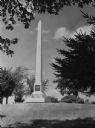
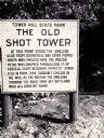
| Description: | The sign marking the location of the shot tower smelter. |
| Date: | 1935 |
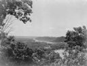
|---|---|
| Description: | Elevated view, looking north, from Mt. Hosmer, with tall bluffs on the far (Wisconsin) side of the Mississippi River. There are multiple sloughs and island... |

| Date: | 1940 |
|---|---|
| Description: | View from shoreline towards two men and two women in bathing suits standing and holding hands while standing in shallow water as a small wave breaks around... |

| Date: | 1940 |
|---|---|
| Description: | An unidentified man and woman are paddling their canoe against the current in the fast running Flambeau River. A small stand of leafless trees and blackene... |

| Date: | 1940 |
|---|---|
| Description: | Two men wearing woolen snowsuits and hats are maneuvering a toboggan over deep snow in a wooded landscape. The sled is loaded with bales of hay and two bus... |
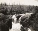
| Date: | |
|---|---|
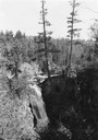
| Description: | Elevated view of Copper Falls on the Bad River. Four people, one man and three women, are posing on rocks at the top of the falls. Surrounding burned-over ... |

| Date: | 09 26 1945 |
|---|---|
| Description: | Elevated view of Peninsula State Park. |
| Date: | |
|---|---|
| Description: | Men lined up for mealtime at the CCC (Civilian Conservation Corps) Camp at Devil's Lake State Park. The camp was reportedly opened in 1935 and closed in 19... |
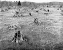
| Date: | |
|---|---|
| Description: | Grass meadow with rotting tree stumps, possibly after a fire. |
If you didn't find the material you searched for, our Library Reference Staff can help.
Call our reference desk at 608-264-6535 or email us at: