 Search: County
Filter: Categories of Wisconsin Historical Images
Search: County
Filter: Categories of Wisconsin Historical Images
| Date: | |
|---|---|
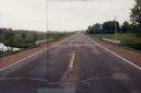
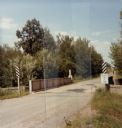
| Description: | Windshield view of rural County Line Road near Marshfield in Wood County. |

| Date: | 1930 |
|---|---|
| Description: | This map shows communities, state roads, county roads, railroads, lakes and rivers in the county. Areas marked in red are lands tax deeded to the county. |
| Date: | 1935 |
|---|---|
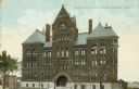
| Description: | The Oneida County Court House. Caption reads: "Oneida County Court House, Rhinelander, Wis." |
| Date: | 1910 |
|---|---|
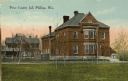
| Description: | View across lawn towards the Price County Jail. Caption reads: "Price County Jail Phillips, Wis." |
| Date: | |
|---|---|
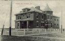
| Description: | View from street towards the county jail (and likely the county courthouse) surrounded by a fence. Caption reads: "County Jail, Hayward, Wis." |

| Date: | 1966 |
|---|---|
| Description: | Overgrown farmstead on County Highway N in Marathon County. |
| Date: | 1920 |
|---|---|
| Description: | The Dane County Courthouse, 207 West Main Street, and Dane County Jail, 219 West Main Street. |

| Date: | 1910 |
|---|---|
| Description: | The Washington County Court House. Caption reads: "Washington County Court House, West Bend, Wis." |

| Date: | 1886 |
|---|---|
| Description: | This map of Ashland County, Wisconsin, which at the time included part of present-day Iron County, also covers portions of Vilas County, Wisconsin, then pa... |
| Date: | |
|---|---|
| Description: | Bridge over the Yellow River on County Highway BB in Wood County. |
| Date: | 1900 |
|---|---|
| Description: | Exterior of the Dane County Courthouse, 207 W. Main Street. Caption reads: "Dane County Courthouse, Madison, Wis." |
| Date: | 1917 |
|---|---|
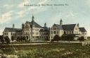
| Description: | The Milwaukee County Alms House. Caption reads: "Milwaukee County Alms House, Wauwatosa, Wis." |

| Date: | 1914 |
|---|---|
| Description: | North part of Waukesha County. From Atlas of Waukesha County. Pages 10 - 11. |

| Date: | 1912 |
|---|---|
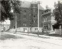
| Description: | Exterior view of the Wood County Insane Asylum. Caption reads: "Wood County Insane Asylum, Marshfield, Wis." |
| Date: | 1980 |
|---|---|
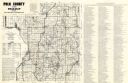
| Description: | This road map of Polk County, Wisconsin, has been annotated to show the location of historic sites in the county and is accompanied by a 1980 directory of ... |
| Date: | 1993 |
|---|---|
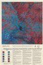
| Description: | This satellite image of Chippewa County, Wisconsin, documents the land use and land cover of the county as recorded June 11, 1992. Accompanying text descri... |

| Date: | 1930 |
|---|---|
| Description: | "Issued by Door County Chamber of Commerce." Shows federal system highways, state highways, county trunk highways, country roads, and parks. Includes direc... |
If you didn't find the material you searched for, our Library Reference Staff can help.
Call our reference desk at 608-264-6535 or email us at:


