 Search: Grant
Search: County
Search: of
Search: Schools
Filter: Categories of Wisconsin Historical Images
Search: Grant
Search: County
Search: of
Search: Schools
Filter: Categories of Wisconsin Historical Images

| Date: | |
|---|---|
| Description: | A map of Grant County, Wisconsin showing the locations of townships, towns, cities, villages, roads, railroads, schools, cemeteries, churches, rivers, and ... |

| Date: | 1889 |
|---|---|
| Description: | Eight diagrams that describe the topography and vegetation of school sections in the towns of Clear Creek and Ludington in Eau Claire County; Sigel in Chip... |

| Date: | 1868 |
|---|---|
| Description: | A detailed, cloth mounted map of Grant County that shows the townships, towns, roads, completed and under construction railroads, cemeteries, mills, lead m... |

| Date: | 1869 |
|---|---|
| Description: | Birds-eye drawing of Boscobel, Grant County, depicts street names and street layouts, houses, rivers and trees. A reference key at the bottom of the map sh... |

| Date: | 1944 |
|---|---|
| Description: | Portage County Map. Includes the towns of Eau Plaine, Dewey, Sharon, Alban, Carson, Hull, New Hope, Linwood, Stockton, Amherst, Plover, Grant, Buena Vista,... |

| Date: | 1910 |
|---|---|
| Description: | This map from the early 20th century shows the Wisconsin Central Railroad land grant lands owned and for sale by the Soo Line in Price County, Wisconsin, a... |

| Date: | 1910 |
|---|---|
| Description: | This map shows the Wisconsin Central Railroad land grant lands owned and for sale by the Soo Line in Taylor County, Wisconsin, as well as in southwestern L... |

| Date: | 1890 |
|---|---|
| Description: | This map shows the Wisconsin Central Railroad land grant lands owned and for sale by the Soo Line in Ashland County, Wisconsin, as well as in portions of B... |

| Date: | 1890 |
|---|---|
| Description: | This 1890s map shows the Wisconsin Central Railroad land grant lands owned and for sale by the Soo Line in Ashland County, Wisconsin, as well as in the eas... |

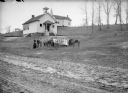
| Date: | |
|---|---|
| Description: | View from dirt road of a clapboard one-room schoolhouse with porch. There is an outhouse behind it near a field. The school was closed as children were giv... |

| Date: | |
|---|---|
| Description: | A map that shows the Wisconsin Central Railway land grant lands for sale by the Soo Line, the Chicago, Milwaukee, and St. Paul Railway. Town sections, lak... |
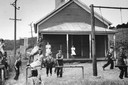
| Date: | 09 1939 |
|---|---|
| Description: | Children play on a playground while a teacher watches from the porch of a one-room schoolhouse. The school building is still located in Grant County, on Hi... |
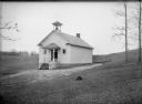
| Date: | |
|---|---|
| Description: | One-room schoolhouse of clapboard with a front door gable roof and a bell tower. |

| Date: | 1965 |
|---|---|
| Description: | This map shows proposed streets, arterial and collector streets, lot numbers and dimensions, parks, the disposal plant, a ball park, and school property. T... |

| Date: | 1915 |
|---|---|
| Description: | This map shows school houses, churches, farms, and railroads. Chequamecon Bay and Bad River Indian Reservation are labeld. The map reads: "All lands shown ... |
| Date: | |
|---|---|
| Description: | View from dirt road of teacher and students posed outside a clapboard schoolhouse with a front door gable roof and a bell tower. On the left side of the sc... |
If you didn't find the material you searched for, our Library Reference Staff can help.
Call our reference desk at 608-264-6535 or email us at: