 Search: Grant
Search: County
Filter: Categories of Wisconsin Historical Images
Filter: Community of Cassville
Search: Grant
Search: County
Filter: Categories of Wisconsin Historical Images
Filter: Community of Cassville
| Date: | |
|---|---|
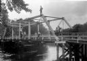
| Description: | View from shoreline of group of people posing on a bridge across a small river near Cassville, probably in Grant County. The group of people, three women, ... |

| Date: | 1850 |
|---|---|
| Description: | This map of Cassville shows plat of the town, roads, landings and public wharfs and the Mississippi River. |
| Date: | 1910 |
|---|---|
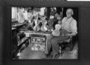
| Description: | A man sits in his shop, holding a violin. Five more violins are arranged next to him. Caption with original negative reads "Old-time fiddle-maker in his sh... |
| Date: | 1935 |
|---|---|
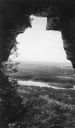
| Description: | A retouched, elevated view, looking out the mouth of a cave, over Nelson Dewey State Park. Far below are a railroad bridge and the backwaters of the Missis... |

| Date: | 10 23 1969 |
|---|---|
| Description: | Deane and Don Oelke, front row, owners of the Denniston House Hotel, standing by the historical marker honoring the history of the Denniston House in Cassv... |

| Date: | 1850 |
|---|---|
| Description: | This map of Cassville shows plat of town, roads, and the Mississippi River. Relief is shown by hachures. The map includes an inset map of a Plat of townshi... |
If you didn't find the material you searched for, our Library Reference Staff can help.
Call our reference desk at 608-264-6535 or email us at: