Search: Grant
Search: County
Filter: Categories of Wisconsin Historical Images
Filter: Subject of cities and towns
Search: Grant
Search: County
Filter: Categories of Wisconsin Historical Images
Filter: Subject of cities and towns
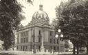
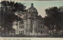
| Date: | 1925 |
|---|---|
| Description: | Exterior view of the Grant County Court House. Caption reads: "Court House, Lancaster, Wis." |
| Date: | 1867 |
|---|---|
| Description: | The Grant County Soldier's Monument was erected in 1866 and dedicated in July of 1867. |
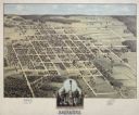
| Date: | 1875 |
|---|---|
| Description: | Bird's-eye map of Lancaster, with inset of Monument for the Soldiers of Grant County. |
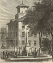
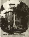
| Date: | 1868 |
|---|---|
| Description: | Elevated view of the Grant County Soldier's Monument. A group of people are standing around the monument. A large building is in the background. Caption at... |

| Date: | |
|---|---|
| Description: | A map of Grant County, Wisconsin showing the locations of townships, towns, cities, villages, roads, railroads, schools, cemeteries, churches, rivers, and ... |
| Date: | 1913 |
|---|---|
| Description: | Corner view of the Grant County courthouse. The Soldiers' Monument and a fountain are in the foreground. A gazebo is under the trees on the right. Caption ... |

| Date: | |
|---|---|
| Description: | A map of Grant County, Wisconsin that shows the townships, cities, villages, rivers and streams, roads and railroads, landownership, post offices. The map... |

| Date: | 1975 |
|---|---|
| Description: | A tourist map of Grant County that displays the various activities and attractions found in the cities throughout the county, such as boat landings, fishin... |
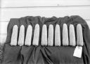
| Date: | |
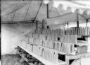
|---|---|
| Description: | Close-up of ten prize winning ears of corn on display at the Grant County Fair. |
| Date: | 1906 |
|---|---|
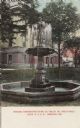
| Description: | Hand-colored postcard of the Memorial Fountain, with the Grant County Courthouse in the background. Caption reads: "Memorial Fountain erected May 30, 1906,... |
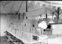
| Date: | 09 17 1912 |
|---|---|
| Description: | Boys and Girls Wisconsin No. 7 Corn Exhibit. J.J. Garland of Madison judged the exhibit. |

| Date: | 1889 |
|---|---|
| Description: | Eight diagrams that describe the topography and vegetation of school sections in the towns of Clear Creek and Ludington in Eau Claire County; Sigel in Chip... |

| Date: | 1868 |
|---|---|
| Description: | A detailed, cloth mounted map of Grant County that shows the townships, towns, roads, completed and under construction railroads, cemeteries, mills, lead m... |

| Date: | 1944 |
|---|---|
| Description: | Portage County Map. Includes the towns of Eau Plaine, Dewey, Sharon, Alban, Carson, Hull, New Hope, Linwood, Stockton, Amherst, Plover, Grant, Buena Vista,... |

| Date: | 1918 |
|---|---|
| Description: | Page from the Standard Atlas of Grant County, Wisconsin of Part of Townships 5 and 6 North, Range 5 West of the 4th P.M. |

| Date: | 1875 |
|---|---|
| Description: | Bird's-eye map of Platteville. |

| Date: | 1942 |
|---|---|
| Description: | This map shows a paper city laid out in 1836 on the Wisconsin River, now the site of Wyalusing State Park, Grant County. The upper right corner includes a ... |
If you didn't find the material you searched for, our Library Reference Staff can help.
Call our reference desk at 608-264-6535 or email us at: