 Search: Madison
Filter: Categories of Wisconsin Historical Images
Filter: Subject of human settlements
Search: Madison
Filter: Categories of Wisconsin Historical Images
Filter: Subject of human settlements
| Date: | |
|---|---|
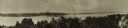
| Description: | Panoramic view of the Madison skyline featuring the Wisconsin State Capitol. |
| Date: | 1974 |
|---|---|
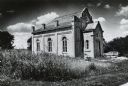
| Description: | The "Gates of Heaven Synagogue" at James Madison Park. |

| Date: | 1890 |
|---|---|
| Description: | Portion of a plat map of Madison featuring Lake Mendota. |

| Date: | 1911 |
|---|---|
| Description: | Map of the west part of the city of Madison. |

| Date: | |
|---|---|
| Description: | View of the Spring Tavern, located on the southern side of Madison. |
| Date: | 08 27 1896 |
|---|---|
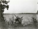
| Description: | View of Madison from across Lake Monona at Turville's Woods. |

| Date: | 1922 |
|---|---|
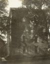
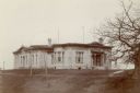
| Description: | Exterior of building on the University of Wisconsin-Madison campus. |
| Date: | 1899 |
|---|---|
| Description: | University of Wisconsin-Madison South Hall, north side. |
| Date: | 1900 |
|---|---|
| Description: | Exterior view of the Washburn Observatory at the University of Wisconsin-Madison. |

| Date: | |
|---|---|
| Description: | Aerial view of Madison featuring Central High School/Madison Area Technical College (MATC) at top center. |

| Date: | |
|---|---|
| Description: | Exterior view of a 5-story brick hospital. Addition attached to an original building. Caption reads: "Madison General Hospital, Madison, Wis." |

| Date: | 1929 |
|---|---|
| Description: | Photograph composite of Madison businesses including Gisholt Machine Company, French Battery and Carbon, Fuller & Johnson MFG., Oscar Mayer, Burgess Batter... |
| Date: | 1897 |
|---|---|
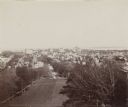
| Description: | Elevated view of the city of Madison, seen from atop Bascom Hill on the University of Wisconsin-Madison campus. |

| Date: | 1890 |
|---|---|
| Description: | Plat map of Madison, T7N R9E, including portions of the towns of Blooming Grove and Burke. Includes inset maps of South Madison, Quarrytown, Marril Park, a... |
| Date: | 1880 |
|---|---|
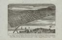
| Description: | Bird's-eye map of the city of Madison. Caption reads: "City of Madison — From Park's 'History of Madison, Dane County, and Surrounding Towns.'" The text un... |
| Date: | 1900 |
|---|---|
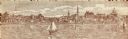
| Description: | A view of the city of Madison circa 1900 that was used as a letterhead. |

| Date: | |
|---|---|
| Description: | University of Wisconsin-Madison Agricultural buildings. The isthmus and Lake Mendota can also be seen. |

| Date: | 1890 |
|---|---|
| Description: | Cyanotype view of side of boathouse on the University of Wisconsin-Madison campus. |
| Date: | 1902 |
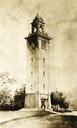
|---|---|
| Description: | Drawing of the University of Wisconsin-Madison Memorial Carillon Tower, designed by J.T.W. Jennings. |
If you didn't find the material you searched for, our Library Reference Staff can help.
Call our reference desk at 608-264-6535 or email us at:
