 Search: Madison
Filter: Categories of Wisconsin Historical Images
Filter: Year of 1900-1999
Filter: Subject of human settlements
Filter: Type of Map or Atlas
Filter: Year of 1930-1939
Search: Madison
Filter: Categories of Wisconsin Historical Images
Filter: Year of 1900-1999
Filter: Subject of human settlements
Filter: Type of Map or Atlas
Filter: Year of 1930-1939

| Date: | 1930 |
|---|---|
| Description: | Lower left hand corner reads: "Compliment of the Madison Association of Commerce MADISON The Four Lake City WISCONSIN." Around the perimeter of the map is ... |

| Date: | 1930 |
|---|---|
| Description: | Indexed map of Madison. Streets, lakes, and points of interest are labelled. Around the edges of the map are the indexed street names. |

| Date: | 1937 |
|---|---|
| Description: | Includes points of interests in Madison and on the University of Wisconsin-Madison campus. Includes list of presidents of University of Wisconsin, 1849-193... |

| Date: | 1934 |
|---|---|
| Description: | This map includes a street index. The map is oriented with the north toward the upper right. Includes handwritten annotations of the 1935 bus routes. |

| Date: | 1930 |
|---|---|
| Description: | This map of Madison is 7 maps showing the city between 1885 and 1930. Each map has its own annotations of population growth, neighborhoods, and other cha... |

| Date: | 1930 |
|---|---|
| Description: | This map shows the western side of Madison, from Nakoma to the capitol. The map is oriented with north to upper right and the scale is indicated by quarter... |

| Date: | 1938 |
|---|---|
| Description: | This map is blue line print and shows local streets, roads, the University of Wisconsin, Monona Village, Verona, Middleton, McFarland, Lake Mendota, Lake M... |
| Date: | 1934 |
|---|---|
| Description: | Blue line print plat map that shows block numbers and dimensions, West Cole Street, Covall Street, Balden St., Parshall Parkway, and the location of the ci... |
| Date: | 1937 |
|---|---|
| Description: | This blue line print map shows highways, the scale of traffic volume, and average 24 hour traffic. Also included are inset maps of Green Bay, Oshkosh, Fond... |
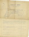
| Date: | 1930 |
|---|---|
| Description: | Shows points of historic interest in Dane County; includes explanation of historical points of interest and corresponding symbols. "Map of historic sites i... |

| Date: | 1934 |
|---|---|
| Description: | A road map of Wisconsin sponsored by Conoco. The front side includes and index, scale, and legend. The reverse side includes United States road map, and i... |

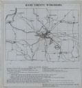
| Date: | 1932 |
|---|---|
| Description: | This map includes a distance table, text, and insets maps of, Superior, Ashland, Marinette, Green Bay, Appleton, Manitowoc, Oshkosh, Fond Du Lac, Janesvill... |
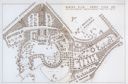
| Date: | 1931 |
|---|---|
| Description: | Fold-out map of the zoo inside a publication titled: "The Master Plan For Henry Vilas Park Zoo." Includes Lake Wingra, the lagoon, and the playground. |

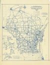
| Date: | 1930 |
|---|---|
| Description: | This map shows the state trunk highway system and county trunk highways. This map show surface type on state and county trunk highways and the locations of... |

| Date: | 1934 |
|---|---|
| Description: | This map shows the state trunk highway system and county trunk highways. This map show surface type on state and county trunk highways and the locations of... |

| Date: | 1938 |
|---|---|
| Description: | This map shows the state trunk highway system and county trunk highways. This map show surface type on state and county trunk highways and the locations of... |

| Date: | 1935 |
|---|---|
| Description: | This map is presented by Conoco, and shows the major roads, cities, lakes, and rivers, as well as some of the neighboring states. It includes an index, sca... |

| Date: | 1931 |
|---|---|
| Description: | This map shows the state trunk highway system and county trunk highways. This map show surface type on state and county trunk highways and the locations of... |

| Date: | 1933 |
|---|---|
| Description: | This map shows the state trunk highway system and county trunk highways. This map show surface type on state and county trunk highways and the locations of... |

| Date: | 1936 |
|---|---|
| Description: | This map shows the state trunk highway system and county trunk highways. This map show surface type on state and county trunk highways and the locations of... |
If you didn't find the material you searched for, our Library Reference Staff can help.
Call our reference desk at 608-264-6535 or email us at: