 Search: Madison
Filter: Categories of Wisconsin Historical Images
Filter: Year of 1900-1999
Filter: Subject of human settlements
Filter: Creator Name of Unknown
Filter: Year of 1960-1969
Search: Madison
Filter: Categories of Wisconsin Historical Images
Filter: Year of 1900-1999
Filter: Subject of human settlements
Filter: Creator Name of Unknown
Filter: Year of 1960-1969

| Date: | 1960 |
|---|---|
| Description: | Exterior view of the Town of Madison town hall building located at 2120 Fish Hatchery Road. |

| Date: | 1960 |
|---|---|
| Description: | Exterior of Field House on the University of Wisconsin-Madison campus. Many of the University's indoor sports events were held here. Camp Randall stadium i... |

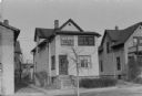
| Date: | 1960 |
|---|---|
| Description: | View from street of houses on the south side of Madison. The cars parked in front of the house are covered in snow. |
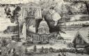
| Date: | 1960 |
|---|---|
| Description: | Views of popular sites in Madison. Numerous different types of recreation are depicted, along with popular sites such as the Wisconsin State Capitol buildi... |

| Date: | 1969 |
|---|---|
| Description: | Wisconsin State Department of Natural Resources Building, 4610 University Avenue. |

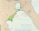
| Date: | 1961 |
|---|---|
| Description: | View over beltline of University of Wisconsin-Madison Arboretum along Lake Wingra. Lake Mendota is on upper left, and Lake Monona is on the right, with the... |

| Date: | 1961 |
|---|---|
| Description: | Shows wards and voting precincts. Published in The Capital times: January 28, 1961. |

| Date: | 1960 |
|---|---|
| Description: | View from street of house numbers 2813-2817 Center Avenue. Two cars parked on the road are covered in snow. |

| Date: | 1967 |
|---|---|
| Description: | Janet Sauk standing outdoors with another woman (possibly her mother) on the day she graduated from the University of Wisconsin-Madison. She is wearing her... |
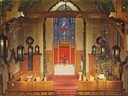
| Date: | 1960 |
|---|---|
| Description: | Elevated view of the interior of the front area in Bethel Lutheran Church, showing the altar and large stained glass window. |

| Date: | 1964 |
|---|---|
| Description: | Indexed map. Street names are to the left, map is to the right. Lakes, streets, highways, and points of interest are labelled. |
| Date: | 1967 |
|---|---|
| Description: | Schematic Master Plan for the City of Madison, Wisconsin. William Wesley Peters, Architect • The Frank Lloyd Wright Foundation. |

| Date: | 1965 |
|---|---|
| Description: | The Harold C. Bradley house, located at 2914 Oxford Road in Shorewood Hills. |

| Date: | 05 22 1963 |
|---|---|
| Description: | View of the Wisconsin State Capitol, probably from Martin Luther King Jr Boulevard. |

| Date: | 1960 |
|---|---|
| Description: | The residence of Lucien M. and Mary Esther "Mollie" Vilas Hanks, 525 Wisconsin Avenue, at the junction of Wisconsin Avenue and Langdon Streets. The home wa... |

| Date: | 04 1960 |
|---|---|
| Description: | Left rear view of White Front Grocery at 610-12 Mound Street in the Grrenbush neighborhood. |
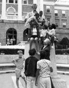
| Date: | 1964 |
|---|---|
| Description: | Governor Warren P. Knowles reaches up to touch the hand of a girl at the Lincoln Memorial on the University of Wisconsin-Madison campus. The girl seated, c... |

| Date: | 1965 |
|---|---|
| Description: | The Robert M. Bashford house at 423 North Pinckney Street. |

| Date: | 1965 |
|---|---|
| Description: | The Harold C. Bradley house at 106 North Prospect Avenue. |
| Date: | 1960 |
|---|---|
| Description: | Front exterior view of a two flat residential building at 612 Milton Street in the Greenbush neighborhood. |
If you didn't find the material you searched for, our Library Reference Staff can help.
Call our reference desk at 608-264-6535 or email us at: