 Search: Madison
Filter: Categories of Wisconsin Historical Images
Filter: Year of 1900-1999
Filter: Subject of human settlements
Filter: Subject of capitols
Search: Madison
Filter: Categories of Wisconsin Historical Images
Filter: Year of 1900-1999
Filter: Subject of human settlements
Filter: Subject of capitols

| Date: | 1978 |
|---|---|
| Description: | Bird’s-eye view map. Shows Madison from the edge of Lake Monona stretching west. Above the map are clouds and in the distance is the edge of the world and ... |

| Date: | 1900 |
|---|---|
| Description: | A view of the city of Madison circa 1900 that was used as a letterhead. |

| Date: | 1920 |
|---|---|
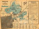
| Description: | A map of Madison and the vicinity. Red lines show the street railway. |

| Date: | 1930 |
|---|---|
| Description: | Indexed map of Madison. Streets, lakes, and points of interest are labelled. Around the edges of the map are the indexed street names. |

| Date: | 1943 |
|---|---|
| Description: | Shows Madison city limits with thick solid lines and ward districts with dotted lines. The wards are numbered, and points of interests and land marks are l... |

| Date: | 1908 |
|---|---|
| Description: | A Sanborn map featuring the Capitol Square and surrounding business district. |
| Date: | 1950 |
|---|---|
| Description: | This map of Madison is also a brochure of activities for vacationers in the area. The map includes indexes and some points of interest are shown pictoriall... |

| Date: | 1924 |
|---|---|
| Description: | Intended for tourists, this brochure, titled: "Plan Now to See Madison, The Four Lake City: "The City Built on an Isthmus," features a map of Madison and s... |

| Date: | 10 1981 |
|---|---|
| Description: | Man rowing scull in water in front of silhouette of the Madison skyline including the Wisconsin State Capitol. |
| Date: | 1971 |
|---|---|
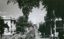
| Description: | View of State Street looking east towards the Wisconsin State Capitol from Bascom Hill (on the University of Wisconsin-Madison campus). The Wisconsin Histo... |

| Date: | 1934 |
|---|---|
| Description: | This map includes a street index. The map is oriented with the north toward the upper right. Includes handwritten annotations of the 1935 bus routes. |

| Date: | 1930 |
|---|---|
| Description: | This map of Madison is 7 maps showing the city between 1885 and 1930. Each map has its own annotations of population growth, neighborhoods, and other cha... |

| Date: | 1930 |
|---|---|
| Description: | This map shows the western side of Madison, from Nakoma to the capitol. The map is oriented with north to upper right and the scale is indicated by quarter... |

| Date: | 1961 |
|---|---|
| Description: | Shows wards and voting precincts. Published in The Capital times: January 28, 1961. |

| Date: | 1968 |
|---|---|
| Description: | This blue line print map shows proposed changes reserving railroad right-of-ways for future highways, land plots, as well as Lake Monona and Lake Mendota. |

| Date: | 1904 |
|---|---|
| Description: | This map shows numbered wards and plots, labelled streets, and parks in green. |

| Date: | 1913 |
|---|---|
| Description: | This map shows city wards and government buildings. The map is oriented with north to upper right. |

| Date: | 1920 |
|---|---|
| Description: | Shows wards and selected points of interest. Includes street index. Oriented with north to upper right. |
If you didn't find the material you searched for, our Library Reference Staff can help.
Call our reference desk at 608-264-6535 or email us at:

