 Search: Madison
Filter: Categories of Wisconsin Historical Images
Filter: Year of 1900-1999
Filter: Subject of human settlements
Filter: Subject of land
Search: Madison
Filter: Categories of Wisconsin Historical Images
Filter: Year of 1900-1999
Filter: Subject of human settlements
Filter: Subject of land
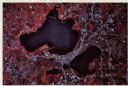
| Date: | 1979 |
|---|---|
| Description: | Text on reverse reads: "Madison, Wisconsin photographed on infrared film at an altitude of 22 miles from a NASA research aircraft. Red = vegetation Blue ... |

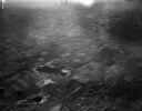
| Date: | 1950 |
|---|---|
| Description: | Aerial view of the Madison isthmus looking north. Caption reads: "Madison Wisconsin — Between Lake Mendota and Lake Monona". |

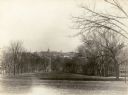
| Date: | 1913 |
|---|---|
| Description: | Exterior view of a hospital building on a hill. Caption reads: "Madison Sanitarium, Madison, Wis." |

| Date: | 1911 |
|---|---|
| Description: | Map of the west part of the city of Madison. |

| Date: | 1911 |
|---|---|
| Description: | View from Bascom Hill of the Engineering Building on the University of Wisconsin-Madison campus. Caption reads: "College of Engineering, Madison." |

| Date: | 1924 |
|---|---|
| Description: | Aerial view of Madison's Willow Beach towards the University of Wisconsin-Madison campus, downtown Madison, and Lake Monona. |
| Date: | 04 21 1948 |
|---|---|
| Description: | Aerial photograph of the west side of Madison and the western edge of Lake Mendota. Taken over the west side of Madison looking northwest toward Middleton. |

| Date: | 1943 |
|---|---|
| Description: | Shows Madison city limits with thick solid lines and ward districts with dotted lines. The wards are numbered, and points of interests and land marks are l... |

| Date: | 1908 |
|---|---|
| Description: | Exterior of Bascom Hall with dome (formerly Main Hall) from Bascom Hill on the University of Wisconsin-Madison campus. Caption reads: "Main Hall, Universit... |

| Date: | 1930 |
|---|---|
| Description: | Aerial view of the University of Wisconsin-Madison Arboretum including the surrounding residential neighborhoods. |
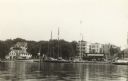
| Date: | 1915 |
|---|---|
| Description: | Mendota Yacht Club, later the site of James Madison Park. |

| Date: | 1925 |
|---|---|
| Description: | View from Olin Park looking at the Madison skyline. |

| Date: | 1910 |
|---|---|
| Description: | Cyanotype view of Science Hall, looking northwest from Bascom Hill, on the University of Wisconsin-Madison campus. |

| Date: | 1908 |
|---|---|
| Description: | Aerial View of University of Wisconsin-Madison College of Agriculture. Lake Mendota with Picnic Point is in the background. |

| Date: | 1900 |
|---|---|
| Description: | Aerial View of University of Wisconsin-Madison College of Agriculture. Lake Mendota with Picnic Point is in the background. |

| Date: | 1946 |
|---|---|
| Description: | University of Wisconsin-Madison campus, looking south from Lake Mendota. Camp Randall stadium is in the upper right. |

| Date: | 1908 |
|---|---|
| Description: | A Sanborn map of the isthmus, which includes the map key. |
| Date: | 1900 |
|---|---|
| Description: | View looking east toward the Wisconsin State Capitol from Bascom Hill on the University of Wisconsin-Madison campus. |
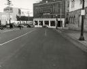
| Date: | 1949 |
|---|---|
| Description: | View downhill towards the intersection of King and Wilson streets. |

| Date: | 1910 |
|---|---|
| Description: | Scale: 1:62500. Topography by Robert Muldrow. Surveyed in 1904. Edition of Aug. 1906, reprinted in 1910. |
If you didn't find the material you searched for, our Library Reference Staff can help.
Call our reference desk at 608-264-6535 or email us at: