Search: Madison
Filter: Categories of Wisconsin Historical Images
Filter: Year of 1900-1999
Filter: Subject of human settlements
Filter: Subject of land use, rural
Search: Madison
Filter: Categories of Wisconsin Historical Images
Filter: Year of 1900-1999
Filter: Subject of human settlements
Filter: Subject of land use, rural

| Date: | 1956 |
|---|---|
| Description: | Aerial view of the new Madison television facility, WISC-TV (Channel 3), showing the transmitting tower in construction. The location is to the southwest,... |

| Date: | 1910 |
|---|---|
| Description: | Map of Dane County rural delivery in Madison and the town of Westport. |

| Date: | 1924 |
|---|---|
| Description: | A map of the Madison Township, T7N R9E including Lake Mendota showing the location of Ho Chunk encampments and effigy mounds. |
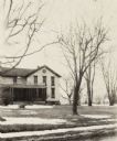
| Date: | 1920 |
|---|---|
| Description: | Exterior of house with porch and yard on highway 113. Snow is on the ground. |
| Date: | 06 1955 |
|---|---|
| Description: | View towards the Wisconsin State Capitol from the outlying area around Madison. Just beyond the cornfield in the foreground are buildings, one with a sign ... |

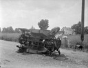
| Date: | 02 08 1950 |
|---|---|
| Description: | Smoldering ruins of the Virgil Normington home in the town of Madison, a half-mile south of the Badger School on E. Badger Road at Rimrock Road. |

| Date: | 1915 |
|---|---|
| Description: | The Lighty house, the home of W.H. Lighty. Left to right: Paul, Harold, Russell, and W.H. Lighty. The house is on the Highlands rural delivery route numb... |

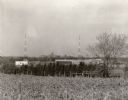
| Date: | 1958 |
|---|---|
| Description: | The Schuepbach Farm off East Clayton Road, with a view of the Wisconsin State Capitol in the far distance. |

| Date: | 1913 |
|---|---|
| Description: | This photocopy map shows plots with owners' names, land use both commercial and agricultural, and lot outlines on University land. Lake Mendota is labeled ... |

| Date: | 1942 |
|---|---|
| Description: | Aerial view of Oscar Mayer & Company, 910 Mayer Avenue at Packers Avenue. Shows stock yards, railroad cars and automobile parking lot. Also shows C.E. & P.... |
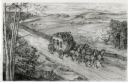
| Date: | 1948 |
|---|---|
| Description: | Drawing of a Madison to Prairie du Chien stage coach in 1848. The coach is driven by two men and drawn by four horses as it passes a farm field separated f... |

| Date: | 1960 |
|---|---|
| Description: | Aerial view of rural landscape with suburban construction in foreground. Cottage Grove Road is at left with the newly constructed Acewood Boulevard crossin... |

| Date: | 10 18 1978 |
|---|---|
| Description: | View down Old Sauk Pass towards a house in a valley during a rainstorm in rural Wisconsin. |
If you didn't find the material you searched for, our Library Reference Staff can help.
Call our reference desk at 608-264-6535 or email us at: