 Search: Madison
Filter: Categories of Wisconsin Historical Images
Filter: Year of 1900-1999
Filter: Subject of human settlements
Filter: Subject of rivers
Search: Madison
Filter: Categories of Wisconsin Historical Images
Filter: Year of 1900-1999
Filter: Subject of human settlements
Filter: Subject of rivers

| Date: | 1930 |
|---|---|
| Description: | Lower left hand corner reads: "Compliment of the Madison Association of Commerce MADISON The Four Lake City WISCONSIN." Around the perimeter of the map is ... |

| Date: | 1905 |
|---|---|
| Description: | View of the lagoon and surrounding wooded area in Tenney Park. Caption reads: "Lagoon in Tenney Park, Madison, Wis." |

| Date: | 1908 |
|---|---|
| Description: | A Sanborn map of the isthmus, which includes the map key. |

| Date: | 1928 |
|---|---|
| Description: | Birds-eye view showing Lake Mendota, Lake Monona, Lake Wingra, Lake Waubesa and Lake Kegonsa. Shows the growth of Madison from the Isthmus along the southe... |

| Date: | 1910 |
|---|---|
| Description: | Scale: 1:62500. Topography by Robert Muldrow. Surveyed in 1904. Edition of Aug. 1906, reprinted in 1910. |

| Date: | 1910 |
|---|---|
| Description: | Map of Dane County rural delivery in Madison and the town of Westport. |
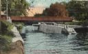
| Date: | 1910 |
|---|---|
| Description: | View of the Sherman Bridge and Lock and surrounding area on the Yahara River. Caption reads: "Sherman Avenue Bridge and Locks, Yahara River, Madison, Wis." |

| Date: | 1909 |
|---|---|
| Description: | View of the lagoon at Tenney Park, surrounded by trees, with a bridge in the distance. Caption reads: "Lagoon and Bridge, Tenney Park, Madison, Wis." |

| Date: | 1908 |
|---|---|
| Description: | Bird's-eye view showing Lake Mendota, Lake Monona, Lake Waubesa, Lake Wingra and Lake Kegonsa. Madison has only the isthmus developed, and there are settle... |

| Date: | 1907 |
|---|---|
| Description: | Bridge and Lagoon in Tenney Park. Caption reads: "Bridge and Lagoon, Tenney Park, Madison, Wisconsin." |

| Date: | 12 16 1949 |
|---|---|
| Description: | Scene along the Yahara River where the body of Max Hobert, a Madison bartender, was found. |

| Date: | 1954 |
|---|---|
| Description: | View of bridge and overhanging tree on Willow Drive at the University. |

| Date: | 1924 |
|---|---|
| Description: | A map of the Madison Township, T7N R9E including Lake Mendota showing the location of Ho Chunk encampments and effigy mounds. |

| Date: | 1917 |
|---|---|
| Description: | Shows property already platted (orange), public property (green), street railway (red lines), Lake Forest development area (red), and some landownership. T... |
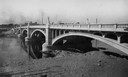
| Date: | 1930 |
|---|---|
| Description: | Madison Street Bridge, built in about 1925. View from shoreline across river with the bridge on the right. |

| Date: | 1905 |
|---|---|
| Description: | This map shows roads, railroads, and location of Keyes Springs, now part of Monona. The map reads: "L.S. Smith, c.e., del. May, 1905" and "For further info... |
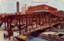
| Date: | 1909 |
|---|---|
| Description: | Color lithograph of elevated view of traffic along the Madison St. bridge. Streetcars, horse-drawn wagons, and pedestrians are on the bridge. Caption reads... |

| Date: | 07 05 1975 |
|---|---|
| Description: | The Tenney Park Bridge over the Yahara River. |

| Date: | 1939 |
|---|---|
| Description: | Several men pass through the locks at the Lake Mendota entrance to the Yahara River. |
If you didn't find the material you searched for, our Library Reference Staff can help.
Call our reference desk at 608-264-6535 or email us at:
