 Search: Madison
Filter: Categories of Wisconsin Historical Images
Filter: Year of 1900-1999
Filter: Subject of human settlements
Filter: Subject of suburbs
Search: Madison
Filter: Categories of Wisconsin Historical Images
Filter: Year of 1900-1999
Filter: Subject of human settlements
Filter: Subject of suburbs
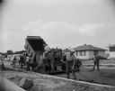
| Date: | 1955 |
|---|---|
| Description: | A construction crew blacktopping a Madison residential street. |
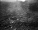
| Date: | 04 21 1948 |
|---|---|
| Description: | Aerial photograph of the west side of Madison and the western edge of Lake Mendota. Taken over the west side of Madison looking northwest toward Middleton. |

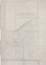
| Date: | 1908 |
|---|---|
| Description: | A Sanborn map of the isthmus, which includes the map key. |
| Date: | 1938 |
|---|---|
| Description: | Architectural drawing of the Sunset Village neighborhood on the West side of the city of Madison. The poster description reads: A proposed master plan for ... |
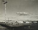
| Date: | 1960 |
|---|---|
| Description: | New residential construction on the outer southwest edge of Madison. |

| Date: | 1955 |
|---|---|
| Description: | Blacktopping a new Madison residential street. Construction of the ranch-style houses in the background is almost complete. |

| Date: | 07 03 1954 |
|---|---|
| Description: | View of the flooded yard of Mr. and Mrs. Willard Stormer at 829 Burbank Place in the Garden Homes subdivision of Madison. |

| Date: | 05 22 1954 |
|---|---|
| Description: | Madison housing development at the corner of McKenna Boulevard and Gilbert Road in the Orchard Ridge neighborhood. Shows homes, sprawling backyards and tel... |

| Date: | 07 03 1954 |
|---|---|
| Description: | Mr. and Mrs. Willard Burbank look at the flooded basement of their home at 829 Burbank Place in the Garden Homes subdivision of Madison. |

| Date: | 1920 |
|---|---|
| Description: | This map shows the Nakoma neighborhood in Madison including the "Proposed Golf Ground." The map reads: "Nakoma--the Suburb Superb." The map includes texts ... |
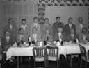
| Date: | 09 10 1952 |
|---|---|
| Description: | Group portrait of the principals and coaches from seven of the nine member schools of the Madison Suburban High School Sports League. |

| Date: | 1966 |
|---|---|
| Description: | This map shows streets, highways, railroads, parks, colleges, cemeteries, county clubs, University of Wisconsin, Truax Field, Middleton, Shorewood Hills, M... |

| Date: | 1971 |
|---|---|
| Description: | This map shows streets, highways, railroads, parks, colleges, cemeteries, county clubs, University of Wisconsin, Truax Field, Middleton, Shorewood Hills, M... |
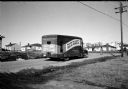
| Date: | 02 09 1954 |
|---|---|
| Description: | The Madison Free Library bookmobile is pulling up in the Lakeview Heights neighborhood, a new city housing development. The bookmobile is an outfitted bus.... |
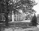
| Date: | 05 24 1934 |
|---|---|
| Description: | The east terrace of the Dr. and Mrs. Frederick Allison Davis home, also known as Edenfred, in the Highlands suburb west of Madison, 6048 S. Highlands Avenu... |

| Date: | 1903 |
|---|---|
| Description: | Shows lot numbers and dimensions. "Issued May 31, 1903" -- Inscribed in ink. Oriented with north to the upper right. Includes text. Labelled streets are "R... |

| Date: | 10 1911 |
|---|---|
| Description: | This map shows lot numbers, building lines, roads, trees, and Indian mounds. Relief is shown by contours. Includes manuscript annotations marking parks. |

| Date: | 06 08 1960 |
|---|---|
| Description: | Blueprint plat of Sunset Hills sub-division. |
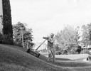
| Date: | 1955 |
|---|---|
| Description: | A man who does odd jobs around his neighborhood mows a banked lawn. |

| Date: | 1906 |
|---|---|
| Description: | This map shows shows streets, subdivisions, railroads, places of interest including the State Capitol, the University of Wisconsin, Camp Randall, Henry Vil... |
If you didn't find the material you searched for, our Library Reference Staff can help.
Call our reference desk at 608-264-6535 or email us at: