Search: Madison
Filter: Categories of Wisconsin Historical Images
Filter: Year of 1900-1999
Filter: Subject of human settlements
Filter: Subject of transportation
Filter: Year of 1940-1949
Search: Madison
Filter: Categories of Wisconsin Historical Images
Filter: Year of 1900-1999
Filter: Subject of human settlements
Filter: Subject of transportation
Filter: Year of 1940-1949

| Date: | 1942 |
|---|---|
| Description: | A detail of a Madison Sanborn map, including Lakelawn Place. |
| Date: | 1940 |
|---|---|
| Description: | View across street of dormitory on the University of Wisconsin-Madison campus. |

| Date: | 1948 |
|---|---|
| Description: | Exterior from south walk of Bascom Hall (formerly Main Hall) on the University of Wisconsin-Madison campus. |

| Date: | 1943 |
|---|---|
| Description: | Shows Madison city limits with thick solid lines and ward districts with dotted lines. The wards are numbered, and points of interests and land marks are l... |
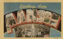
| Date: | 1949 |
|---|---|
| Description: | Large Letter style postcard with the Capitol in the foreground, and other buildings within the letters of Madison. Text on back reads: "Madison is the capi... |

| Date: | 1946 |
|---|---|
| Description: | University of Wisconsin-Madison campus, looking south from Lake Mendota. Camp Randall stadium is in the upper right. |

| Date: | 1948 |
|---|---|
| Description: | View towards Lake Mendota from the Memorial Union terrace on the University of Wisconsin-Madison campus. |
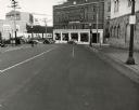
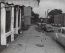
| Date: | 1949 |
|---|---|
| Description: | View downhill towards the intersection of King and Wilson streets. |

| Date: | 1947 |
|---|---|
| Description: | University of Wisconsin-Madison, from Park Street to the men's dormitories. Part of Lake Mendota is in the top right corner. |

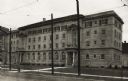
| Date: | 1948 |
|---|---|
| Description: | Mrs. Clara Hatch residence, 901 West Johnson Street. |
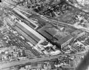
| Date: | 10 18 1945 |
|---|---|
| Description: | Madison Ray-O-Vac plant, 2313-25 Winnebago Street. |

| Date: | 1946 |
|---|---|
| Description: | University of Wisconsin-Madison buildings. The General Hospital is in the center, surrounded by homes, trees, and other university buildings. |

| Date: | 1945 |
|---|---|
| Description: | West side of South Hall on the University of Wisconsin-Madison campus. The facade is covered with vines. |

| Date: | 11 20 1947 |
|---|---|
| Description: | Madison Free Library, 206 North Carroll Street. The library was built with Carnegie money and opened in 1906. The name changed to Madison Public Library ... |

| Date: | 1942 |
|---|---|
| Description: | Detail of a Madison Sanborn Map showing the Lake Mendota shoreline. The area shown is between the Blackhawk Country Club and Eagle Heights Woods. |

| Date: | 1948 |
|---|---|
| Description: | View from Lake Mendota of boathouse on the University of Wisconsin-Madison campus. The Armory (Red Gym or Old Red) is behind the boathouse. A person is sit... |

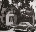
| Date: | 1948 |
|---|---|
| Description: | The residence of "Cap" Barnes at 129 North Baldwin Street. |
If you didn't find the material you searched for, our Library Reference Staff can help.
Call our reference desk at 608-264-6535 or email us at: