 Search: Madison
Filter: Categories of Wisconsin Historical Images
Filter: Year of 1900-1999
Filter: Year of 1900-1909
Filter: Subject of human settlements
Search: Madison
Filter: Categories of Wisconsin Historical Images
Filter: Year of 1900-1999
Filter: Year of 1900-1909
Filter: Subject of human settlements
| Date: | 1905 |
|---|---|
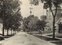
| Description: | Langdon Street and the lower campus of the University of Wisconsin, including the Armory (Red Gym or Old Red). |
| Date: | 1900 |
|---|---|
| Description: | View from hill towards Lake Mendota and the surrounding neighborhood, looking northwest from Observatory Hill. |

| Date: | 1908 |
|---|---|
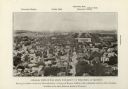
| Description: | Colored map showing a panoramic view of Madison in great detail. The Wisconsin State Capitol is located at the center, with Lake Mendota in the background ... |
| Date: | 1901 |
|---|---|
| Description: | Elevated view looking west down State Street towards the University of Wisconsin. Caption reads: "General View of the State University of Wisconsin, at Mad... |

| Date: | 1900 |
|---|---|
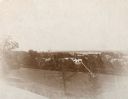
| Description: | Panoramic view of campus from a frozen and snow-covered Lake Mendota at the University of Wisconsin-Madison. Park Street and Science Hall are visible on th... |
| Date: | 1900 |
|---|---|
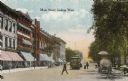
| Description: | View down Main Street on the Capitol Square. Caption reads: "Main Street, looking West." |

| Date: | 1909 |
|---|---|
| Description: | Streets, Lake Wingra, Lake Mendota, and Lake Monona are all labelled. Map reads: "The present park system of Madison comprises 150 acres of improved parks,... |
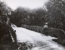
| Date: | 1902 |
|---|---|
| Description: | Rustic bridge over a ravine on Lake Mendota Drive in Shorewood Hills. |

| Date: | 1905 |
|---|---|
| Description: | Caption reads: "South Side, Madison Ave. at Grantsburg, Wis." View across road towards pedestrians and horse-drawn wagons at the curb. |

| Date: | 1905 |
|---|---|
| Description: | A drawing by State Architect, Arthur Peabody, depicting the proposed State Street facade of the University Club building. |
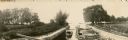
| Date: | 1906 |
|---|---|
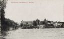
| Description: | A boat full of men and women is entering the lock on the Yahara River at Tenney Park. |
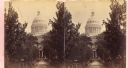
| Date: | 1904 |
|---|---|
| Description: | A view of the tree-lined walkway leading up to the entrance of the Capitol building. |

| Date: | 1906 |
|---|---|
| Description: | State Street with torn up streetcar lines, looking east from Park Street. |

| Date: | 1908 |
|---|---|
| Description: | The map reads: "Feb. 3, 1908." Oriented with north to the lower left. Lake Monona, Monona Bay, and Brittingham Park are labelled. |

| Date: | 06 30 1903 |
|---|---|
| Description: | Exterior view of Agriculture Hall soon after completion. |

| Date: | 1905 |
|---|---|
| Description: | This blueprint map includes manuscript annotations in red showing land of Home Realty Co., Hon. Geo. B. Burrows, and A.O. Fox Industrial. |
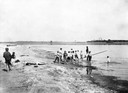
| Date: | 1905 |
|---|---|
| Description: | Group of children playing with a makeshift diving board at Brittingham Bay swimming hole. |

| Date: | 1905 |
|---|---|
| Description: | View across Main Street towards the Park Hotel on a corner. A church is behind the hotel on the left. In the left foreground a man is entering a horse-draw... |
| Date: | 1900 |
|---|---|
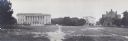
| Description: | Panoramic view of University of Wisconsin-Madison campus, with the Wisconsin State Historical Library, old Y.M.C.A., and Armory (Red Gym or Old Red). The b... |
| Date: | 1900 |
|---|---|
| Description: | View from Lake Mendota of buildings on the University of Wisconsin-Madison campus. The boathouse, Armory (later the Red Gym or Old Red), and Science Hall c... |
If you didn't find the material you searched for, our Library Reference Staff can help.
Call our reference desk at 608-264-6535 or email us at: