 Search: Madison
Filter: Categories of Wisconsin Historical Images
Filter: Year of 1900-1999
Filter: Year of 1900-1909
Filter: Subject of neighborhoods
Search: Madison
Filter: Categories of Wisconsin Historical Images
Filter: Year of 1900-1999
Filter: Year of 1900-1909
Filter: Subject of neighborhoods
| Date: | 1900 |
|---|---|
| Description: | Exterior view of the Executive Mansion in Madison. |

| Date: | 08 1902 |
|---|---|
| Description: | A detail of a Madison Sanborn map showing Mendota Court. |

| Date: | 1908 |
|---|---|
| Description: | A Sanborn map featuring the Capitol Square and surrounding business district. |

| Date: | 1908 |
|---|---|
| Description: | A Sanborn map including a portion of the East Johnson Street and East Gorham Street neighborhood. |
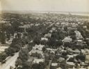
| Date: | 1907 |
|---|---|
| Description: | Elevated view looking toward the Wisconsin State Capitol along University Avenue, possibly from the chimney of University of Wisconsin-Madison Power Statio... |

| Date: | 1907 |
|---|---|
| Description: | This manuscript blueprint map shows land parcels pertaining to University Heights region in Madison, Wisconsin. Streets labeled included, University Avenue... |

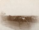
| Date: | 1908 |
|---|---|
| Description: | Aerial view of Camp Randall Field on the University of Wisconsin-Madison campus. University Heights is in the background. |
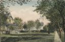
| Date: | 1908 |
|---|---|
| Description: | View looking down a sidewalk on the left side of Madison Avenue. Trees line the terrace, and houses and lawns are on the left. Caption reads: "Madison Aven... |

| Date: | 1905 |
|---|---|
| Description: | View of Madison in the far distance taken from the third floor of a home at 216 Campbell Street, in University Heights. There is a power line suspended in ... |
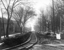
| Date: | 1906 |
|---|---|
| Description: | Newly-constructed streetcar tracks on Park Street, looking south from State Street. The eastern edge of the University of Wisconsin-Madison campus can be s... |
| Date: | 1908 |
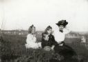
|---|---|
| Description: | Four girls are sitting on a hill in University Heights. The city of Madison is in the background. |

| Date: | 1907 |
|---|---|
| Description: | Elevated view looking southeast, possibly from the chimney of the University of Wisconsin Power Plant. |

| Date: | 1908 |
|---|---|
| Description: | A detail of a Sanborn map showing the area around North Franklin, North Blair and North Hancock Streets. |

| Date: | 1908 |
|---|---|
| Description: | Panoramic view of Madison taken from Summit Avenue looking East South East toward Lake Monona. Included in the view are the Camp Randall bleachers, St. Rap... |

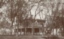
| Date: | 1900 |
|---|---|
| Description: | The residence at 323 North Carroll Street of Dr. and Mrs. James A. and Josephine S. Jackson from 1895 to the 1930s. |
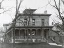
| Date: | 1900 |
|---|---|
| Description: | The Joseph William Hobbins House at 114 West Gilman. Two woman are standing on the front porch. |

| Date: | 1900 |
|---|---|
| Description: | Elevated view looking towards Monona Bay, possibly from atop the University of Wisconsin Power Plant smokestack. |

| Date: | 1904 |
|---|---|
| Description: | This map shows numbered wards and plots, labelled streets, and parks in green. |
| Date: | 1900 |
|---|---|
| Description: | View from hill towards Lake Mendota and the surrounding neighborhood, looking northwest from Observatory Hill. |
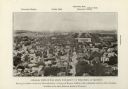
| Date: | 1901 |
|---|---|
| Description: | Elevated view looking west down State Street towards the University of Wisconsin. Caption reads: "General View of the State University of Wisconsin, at Mad... |
If you didn't find the material you searched for, our Library Reference Staff can help.
Call our reference desk at 608-264-6535 or email us at: