 Search: Madison
Filter: Categories of Wisconsin Historical Images
Filter: Year of 1900-1999
Filter: Year of 1900-1909
Filter: Subject of streets
Search: Madison
Filter: Categories of Wisconsin Historical Images
Filter: Year of 1900-1999
Filter: Year of 1900-1909
Filter: Subject of streets

| Date: | 1908 |
|---|---|
| Description: | Sanborn map of Madison, including West Gilman and Langdon Streets. |

| Date: | 1902 |
|---|---|
| Description: | Madison Sanborn map, including Langdon and State Streets. |
| Date: | 1905 |
|---|---|
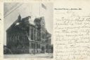
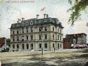
| Description: | The Dane County Courthouse. Caption reads: "The Court House — Madison, Wis." |
| Date: | 1909 |
|---|---|
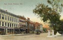
| Description: | View of Main Street with streetcar. Caption reads: "Main Street, Madison, Wis." |
| Date: | 1909 |
|---|---|
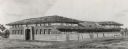
| Description: | Architectural drawing. Caption reads: "Market House for the City of Madison". Robert L. Wright, Milwaukee, architect. |

| Date: | 1900 |
|---|---|
| Description: | Colorized depiction of City Hall, 2 West Mifflin Street. Caption reads: "City Hall, Madison, Wis." |

| Date: | 08 1902 |
|---|---|
| Description: | A detail of a Madison Sanborn map showing Mendota Court. |
| Date: | 1907 |
|---|---|
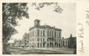
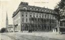
| Description: | Exterior view of City Hall on Mifflin Street. Caption reads: "City Hall & Mifflin St., Madison, Wis." |

| Date: | 1905 |
|---|---|
| Description: | View across intersection towards the Park Hotel, located on the Capitol Square. Caption reads: "Park Hotel, Madison, Wis." |
| Date: | 1908 |
|---|---|
| Description: | Colorized view of the U.S. Post Office and its surrounding streets. Caption reads: "Post Office, Madison, Wis." |
| Date: | 1907 |
|---|---|
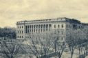
| Description: | Elevated view of the State Historical Society from the Armory. Caption reads: "State Historical Library, Madison, Wis." |

| Date: | 1908 |
|---|---|
| Description: | A Sanborn map of the isthmus, which includes the map key. |

| Date: | 1908 |
|---|---|
| Description: | A Sanborn map featuring the Capitol Square and surrounding business district. |

| Date: | 1908 |
|---|---|
| Description: | A Sanborn map including a portion of the East Johnson Street and East Gorham Street neighborhood. |

| Date: | 1907 |
|---|---|
| Description: | Elevated view on Main Street on the Capitol Square. Caption reads: "Main St., looking West, Madison, Wis." |

| Date: | 1907 |
|---|---|
| Description: | Elevated view of Main Street on the Capitol Square. Caption reads: "Main St., looking West, Madison, Wis." |
| Date: | 1900 |
|---|---|
| Description: | View across intersection towards the Park Hotel, located on the Capitol Square. Caption reads: "Park Hotel, Madison, Wis." |

| Date: | 1902 |
|---|---|
| Description: | View across Mifflin Street towards the old Madison Post Office, with a streetcar stopped in front of the building. |

| Date: | 1905 |
|---|---|
| Description: | Elevated view from the Wisconsin State Capitol of State Street looking west, toward the University of Wisconsin-Madison and Bascom Hall. |
If you didn't find the material you searched for, our Library Reference Staff can help.
Call our reference desk at 608-264-6535 or email us at:
