 Search: Madison
Filter: Categories of Wisconsin Historical Images
Filter: Year of 1900-1999
Filter: Year of 1900-1909
Filter: Subject of universities and colleges
Search: Madison
Filter: Categories of Wisconsin Historical Images
Filter: Year of 1900-1999
Filter: Year of 1900-1909
Filter: Subject of universities and colleges

| Date: | 1908 |
|---|---|
| Description: | Aerial View of University of Wisconsin-Madison College of Agriculture. Lake Mendota with Picnic Point is in the background. |

| Date: | 1900 |
|---|---|
| Description: | Aerial View of University of Wisconsin-Madison College of Agriculture. Lake Mendota with Picnic Point is in the background. |

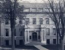
| Date: | 1907 |
|---|---|
| Description: | Exterior of Engineering Building along Bascom Hill on the University of Wisconsin-Madison campus. Later this became the Education building. Caption reads: ... |
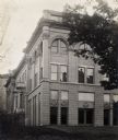
| Date: | 1901 |
|---|---|
| Description: | East side view of the Engineering Building, located on Bascom Hill, on the University of Wisconsin-Madison campus. |
| Date: | 1901 |
|---|---|
| Description: | Exterior of entrance to the Engineering Building along Bascom Hill on the University of Wisconsin-Madison campus. Later this became the Education building. |

| Date: | 1907 |
|---|---|
| Description: | Exterior view from west of University of Wisconsin-Madison College of Agriculture. Trees and a sidewalk line the open lawn on the right. Several buildings... |
| Date: | 1900 |
|---|---|
| Description: | Exterior view from west of University of Wisconsin-Madison College of Agriculture on a hill on campus. Trees and a sidewalk line the open lawn on the right... |

| Date: | 1900 |
|---|---|
| Description: | This map shows the expansion of the University of Wisconsin-Madison campus growth between the years of 1850 and 1900. The map is indexed by building name a... |

| Date: | 1908 |
|---|---|
| Description: | Exterior view from west of University of Wisconsin-Madison College of Agriculture. Trees and a sidewalk line the open lawn on the right. Several buildings ... |

| Date: | 1900 |
|---|---|
| Description: | A class of engineering students practicing surveying in front of Science Hall, located on the University of Wisconsin (Madison) campus. Eleven engineering ... |
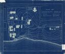
| Date: | 1905 |
|---|---|
| Description: | This blueprint map shows campus buildings, roads, and Lake Mendota. The compass rose near the title is incorrect; the map is actually oriented with north t... |

| Date: | 1907 |
|---|---|
| Description: | Elevated view looking northeast from the chimney of the Power Plant on University Avenue. The Chemistry Building is in the foreground, and Bascom Hall and ... |

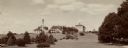
| Date: | 1907 |
|---|---|
| Description: | Elevated view looking northeast from the chimney of the Power Plant on University Avenue. The Chemistry Building is in the foreground, and Bascom Hall and ... |
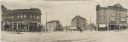
| Date: | 05 07 1907 |
|---|---|
| Description: | Panoramic view of the downtown towards Bascom Hall from the corner of the Capitol Square, showing Carroll, Mifflin, and State Streets. Several businesses c... |

| Date: | 1903 |
|---|---|
| Description: | This map is ink on printed paper reading: "standard profile plate." "Surveyed Oct. 15, platted Dec. 15, 1903 ; surveyed May 9, platted Dec. 9." |
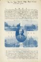
| Date: | 03 01 1903 |
|---|---|
| Description: | An article in Tokyo publication the "Sun Trade Journal" featuring Richard Ely, along with images of the main buildings of the University of Wisconsin-Madis... |
If you didn't find the material you searched for, our Library Reference Staff can help.
Call our reference desk at 608-264-6535 or email us at: