 Search: Madison
Filter: Categories of Wisconsin Historical Images
Filter: Year of 1900-1999
Filter: Year of 1900-1909
Filter: Subject of wetlands
Search: Madison
Filter: Categories of Wisconsin Historical Images
Filter: Year of 1900-1999
Filter: Year of 1900-1909
Filter: Subject of wetlands
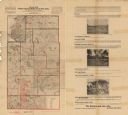
| Date: | 1900 |
|---|---|
| Description: | This map from the turn of the 20th century shows the township and range grid, sections, towns, land owned by the Starks Levis Land Company of Madison, scho... |
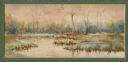
| Date: | 1906 |
|---|---|
| Description: | Watercolor painting of the Yahara River at Lake Monona, with trees in the background and wetlands in the foreground. |
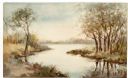
| Date: | 1906 |
|---|---|
| Description: | Watercolor painting of the Yahara River, with large trees on the shoreline. Note: '05 & '06 were the years when Tenney Park and the Yahara River Parkway ... |
If you didn't find the material you searched for, our Library Reference Staff can help.
Call our reference desk at 608-264-6535 or email us at: