Search: Madison
Filter: Categories of Wisconsin Historical Images
Filter: Year of 1900-1999
Filter: Year of 1950-1959
Filter: Creator Name of Newhouse, John
Filter: Subject of intellectual life
Search: Madison
Filter: Categories of Wisconsin Historical Images
Filter: Year of 1900-1999
Filter: Year of 1950-1959
Filter: Creator Name of Newhouse, John
Filter: Subject of intellectual life
| Date: | 1956 |
|---|---|
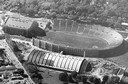
| Description: | Aerial view of Camp Randall Stadium and Field House on the University of Wisconsin-Madison campus. |

| Date: | 1956 |
|---|---|
| Description: | Aerial view of the new Madison television facility, WISC-TV (Channel 3), showing the transmitting tower in construction. The location is to the southwest,... |
| Date: | 1958 |
|---|---|
| Description: | Aerial view of the construction of the lakeshore dormitories, the recreation facilities and Lake Mendota on the University of Wisconsin Madison campus. |

| Date: | 1954 |
|---|---|
| Description: | An aerial view of the State Office Building, 1 West Wilson Street. Also shows Olin Terrace, Madison Club and the United States Post Office. |

| Date: | 1956 |
|---|---|
| Description: | Aerial view of upper campus of the University of Wisconsin-Madison with Lake Mendota. |

| Date: | 1957 |
|---|---|
| Description: | An aerial view of Edgewood College and Schools. |
| Date: | 1958 |
|---|---|
| Description: | Aerial view of Orchard Ridge School, at 5602 Russett Road. |

| Date: | 1956 |
|---|---|
| Description: | Aerial view over University Avenue of the University of Wisconsin-Madison campus, including University farm in the upper middle. The shoreline of Lake Mend... |

| Date: | 1956 |
|---|---|
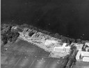
| Description: | Aerial view of St. Mary's Hospital and the surrounding residential neighborhoods. |
| Date: | 1954 |
|---|---|
| Description: | An air view of Madison including the Veterans Hospital, Forest Products Laboratory and University Avenue from Farley (lower edge), to Allen Streets. |

| Date: | 1956 |
|---|---|
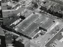
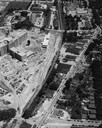
| Description: | Aerial view of the South Park Street interchange. |

| Date: | 1956 |
|---|---|
| Description: | Aerial view of Wisconsin General Hospital. |
| Date: | 1956 |
|---|---|
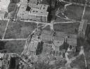
| Description: | Aerial view of Birge and Bascom Halls (formerly Main Hall) on the University of Wisconsin-Madison campus. Birge Hall (foreground) with addition under cons... |
| Date: | 1958 |
|---|---|
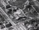
| Description: | Aerial view of Chadbourne Hall under construction on the University of Wisconsin-Madison campus. The new building is at the corner of Park Street and Unive... |
| Date: | 1958 |
|---|---|
| Description: | Aerial view of Chadbourne Hall under construction on the University of Wisconsin-Madison campus at the corner of Park Street and University Avenue. Music H... |
| Date: | 1958 |
|---|---|
| Description: | Aerial View of Eagle Heights Apartments, built especially for married students' housing, under construction on the University of Wisconsin-Madison campus. ... |
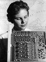
| Date: | 1950 |
|---|---|
| Description: | Jean Hoffman looks over a printed circuit board in the foreground, with a map of Madison, Wisconsin on the wall behind her. |
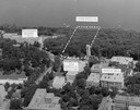
| Date: | 1958 |
|---|---|
| Description: | Aerial view of upper campus on the University of Wisconsin-Madison. Typewritten labels mark the location of Elizabeth Waters Hall, New Commerce Building, L... |

| Date: | 06 07 1954 |
|---|---|
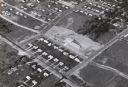
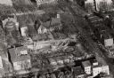
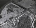
| Description: | Aerial view of the Midvale neighborhood under construction showing the intersection of Midvale and Tokay Boulevards near the southwestern city limits of Ma... |
If you didn't find the material you searched for, our Library Reference Staff can help.
Call our reference desk at 608-264-6535 or email us at: