Search: Madison
Filter: Categories of Wisconsin Historical Images
Filter: Year of 1900-1999
Filter: Year of 1950-1959
Filter: Subject of aerial photographs
Search: Madison
Filter: Categories of Wisconsin Historical Images
Filter: Year of 1900-1999
Filter: Year of 1950-1959
Filter: Subject of aerial photographs

| Date: | 04 27 1951 |
|---|---|
| Description: | A composite map of the Madison area taken from aerial photos by Abrams Aerial Survey Corporation for the Madison Planning Commission. |
| Date: | 1956 |
|---|---|
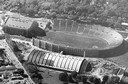
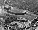
| Description: | Aerial view of Camp Randall Stadium and Field House on the University of Wisconsin-Madison campus. |

| Date: | 10 17 1952 |
|---|---|
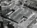
| Description: | Aerial view of Madison General Hospital and surrounding neighborhood. |

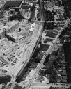
| Date: | 05 11 1951 |
|---|---|
| Description: | Aerial view of downtown Madison looking from State Street to King Street. |

| Date: | 1956 |
|---|---|
| Description: | Aerial view of the new Madison television facility, WISC-TV (Channel 3), showing the transmitting tower in construction. The location is to the southwest,... |
| Date: | 1954 |
|---|---|
| Description: | Aerial view of Camp Randall Stadium and Field House on the University of Wisconsin-Madison campus. |
| Date: | 1958 |
|---|---|
| Description: | Aerial view of the construction of the lakeshore dormitories, the recreation facilities and Lake Mendota on the University of Wisconsin Madison campus. |

| Date: | 1954 |
|---|---|
| Description: | An aerial view of the State Office Building, 1 West Wilson Street. Also shows Olin Terrace, Madison Club and the United States Post Office. |

| Date: | 05 11 1951 |
|---|---|
| Description: | Aerial view of downtown Madison looking from West Washington Avenue to East Washington Avenue. |

| Date: | 10 17 1952 |
|---|---|
| Description: | Aerial view of Madison General Hospital and the surrounding Greenbush and Vilas neighborhoods with Camp Randall and Lake Mendota in the background. |

| Date: | 10 18 1952 |
|---|---|
| Description: | Aerial view of Madison General Hospital, the surrounding Greenbush and Vilas neighborhoods, and Camp Randall in the background. |

| Date: | 1956 |
|---|---|
| Description: | Aerial view of upper campus of the University of Wisconsin-Madison with Lake Mendota. |

| Date: | 1957 |
|---|---|
| Description: | An aerial view of Edgewood College and Schools. |
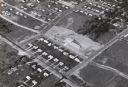
| Date: | 1958 |
|---|---|
| Description: | Aerial view of Orchard Ridge School, at 5602 Russett Road. |

| Date: | 10 18 1952 |
|---|---|
| Description: | Aerial view of Madison General Hospital and the surrounding Greenbush and Vilas neighborhoods. Also visible is Monona Bay with Camp Randall and Picnic Poi... |

| Date: | 1956 |
|---|---|
| Description: | Aerial view over University Avenue of the University of Wisconsin-Madison campus, including University farm in the upper middle. The shoreline of Lake Mend... |

| Date: | 1956 |
|---|---|
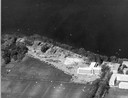
| Description: | Aerial view of St. Mary's Hospital and the surrounding residential neighborhoods. |
| Date: | 1954 |
|---|---|
| Description: | An air view of Madison including the Veterans Hospital, Forest Products Laboratory and University Avenue from Farley (lower edge), to Allen Streets. |

| Date: | 06 17 1952 |
|---|---|
| Description: | Aerial photos probably of Madison, looking north east from intersection of Nakoma Road (Hwy. 18-151) and West Beltline Highway (Hwy. 12-18) toward Isthmus,... |
If you didn't find the material you searched for, our Library Reference Staff can help.
Call our reference desk at 608-264-6535 or email us at: