 Search: Madison
Filter: Categories of Wisconsin Historical Images
Filter: Year of 1900-1999
Filter: Year of 1950-1959
Filter: Subject of express highways
Search: Madison
Filter: Categories of Wisconsin Historical Images
Filter: Year of 1900-1999
Filter: Year of 1950-1959
Filter: Subject of express highways

| Date: | 05 11 1959 |
|---|---|
| Description: | Three people are injured in a two car crash on USH 12 & 18 at the Madison east side city limits at a location referred to as "Crash Curve" by law enforceme... |

| Date: | 1953 |
|---|---|
| Description: | This map shows local streets, roads, highways, Middleton, Monona, Lake Wingra, Lake Monona, Lake Mendota, and an inset map that shows city parking areas. A... |
| Date: | 10 11 1950 |
|---|---|
| Description: | Display illustrating the Highway Department's plan for separating highway traffic on Highways 13 and 14 (the Oregon Road) and Highway 12 (the new South Mad... |

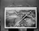
| Date: | 1950 |
|---|---|
| Description: | This road map shows federal, state and county roads in Wisconsin, northern Illinois, northeastern Iowa, eastern Minnesota, and the western portion of Michi... |
If you didn't find the material you searched for, our Library Reference Staff can help.
Call our reference desk at 608-264-6535 or email us at: