 Search: Madison
Filter: Categories of Wisconsin Historical Images
Filter: Year of 1900-1999
Filter: Year of 1950-1959
Filter: Subject of lakes
Search: Madison
Filter: Categories of Wisconsin Historical Images
Filter: Year of 1900-1999
Filter: Year of 1950-1959
Filter: Subject of lakes

| Date: | 1950 |
|---|---|
| Description: | Aerial view of the Madison isthmus looking north. Caption reads: "Madison Wisconsin — Between Lake Mendota and Lake Monona". |

| Date: | 04 27 1951 |
|---|---|
| Description: | A composite map of the Madison area taken from aerial photos by Abrams Aerial Survey Corporation for the Madison Planning Commission. |
| Date: | 1958 |
|---|---|
| Description: | Aerial view of the construction of the lakeshore dormitories, the recreation facilities and Lake Mendota on the University of Wisconsin Madison campus. |

| Date: | 1959 |
|---|---|
| Description: | University of Wisconsin-Madison campus. Numbers in circles identify buildings across campus with the building index. Black arrows point out important infor... |
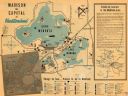
| Date: | 1950 |
|---|---|
| Description: | This map of Madison is also a brochure of activities for vacationers in the area. The map includes indexes and some points of interest are shown pictoriall... |

| Date: | 10 25 1958 |
|---|---|
| Description: | Sailboats on a Madison lake, it is unclear whether it is Lake Mendota or Lake Monona. Trees are along the far shoreline. |

| Date: | 1956 |
|---|---|
| Description: | Aerial view of upper campus of the University of Wisconsin-Madison with Lake Mendota. |
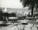
| Date: | 1952 |
|---|---|
| Description: | University of Wisconsin-Madison Memorial Union Terrace with Lake Mendota and sailboats in the background. |
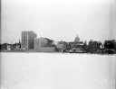
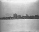
| Date: | 12 18 1955 |
|---|---|
| Description: | Downtown Madison lakeshore taken from Lake Monona in line with South Pinckney Street. Includes St. Raphael's steeple, 1 West Wilson Street state office bui... |

| Date: | 10 18 1952 |
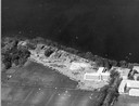
|---|---|
| Description: | Aerial view of Madison General Hospital and the surrounding Greenbush and Vilas neighborhoods. Also visible is Monona Bay with Camp Randall and Picnic Poi... |

| Date: | 1955 |
|---|---|
| Description: | Shows city limits, adjoining municipalities, and schools. Indexes, illustrations, ancillary map of Dane County, and ancillary map of Madison business secti... |

| Date: | 1956 |
|---|---|
| Description: | Aerial view over University Avenue of the University of Wisconsin-Madison campus, including University farm in the upper middle. The shoreline of Lake Mend... |

| Date: | 06 17 1952 |
|---|---|
| Description: | Aerial photos probably of Madison, looking north east from intersection of Nakoma Road (Hwy. 18-151) and West Beltline Highway (Hwy. 12-18) toward Isthmus,... |

| Date: | 07 09 1953 |
|---|---|
| Description: | View of the pier at B.B. Clarke on Lake Monona, scene of the Madison city swim meet. |

| Date: | 1956 |
|---|---|
| Description: | Map reads: "TAX EXEMPT LAND in the CITY OF MADISON". There is a legend of "Government Land" represented in stripes, "Religious and Fraternal Organization" ... |
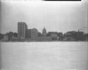
| Date: | 12 18 1955 |
|---|---|
| Description: | Downtown Madison lakeshore taken from Lake Monona in line with South Pinckney Street. Includes 1 West Wilson Street state office building, the Wisconsin St... |

| Date: | 1953 |
|---|---|
| Description: | Illustrated postcard of an elevated view of Monona Bay, the Isthmus and Lake Mendota. A residential neighborhood is in the foreground. Caption reads: "Madi... |
| Date: | 12 18 1955 |
|---|---|
| Description: | Downtown Madison shoreline taken from Lake Monona in line with Monona Avenue (Martin Luther King, Jr. Boulevard as of January 19, 1987). Includes Wisconsi... |
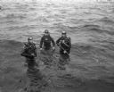
| Date: | 11 08 1956 |
|---|---|
| Description: | Madison Diving Club members Harold Stitgen, president, Reverend Herbert Schaak, treasurer, and James Filer dressed for scuba diving in Lake Mendota off Con... |
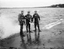
| Date: | 11 08 1956 |
|---|---|
| Description: | Madison Diving Club members Harold Stitgen, president, Reverend Herbert Schaak, treasurer, and James Filer wearing diving suits and scuba gear, ready for a... |
If you didn't find the material you searched for, our Library Reference Staff can help.
Call our reference desk at 608-264-6535 or email us at: