Search: Madison
Filter: Categories of Wisconsin Historical Images
Filter: Year of 1900-1999
Filter: Year of 1950-1959
Filter: Subject of land use, urban
Search: Madison
Filter: Categories of Wisconsin Historical Images
Filter: Year of 1900-1999
Filter: Year of 1950-1959
Filter: Subject of land use, urban

| Date: | 1956 |
|---|---|
| Description: | Aerial view over University Avenue of the University of Wisconsin-Madison campus, including University farm in the upper middle. The shoreline of Lake Mend... |

| Date: | 06 16 1958 |
|---|---|
| Description: | Leaders in the Madison metropolitan area met to learn more about the Madison Improvement Corporation, whose purpose is to buy and develop land for the expa... |

| Date: | 1956 |
|---|---|
| Description: | Aerial view of the South Park Street interchange. |

| Date: | 06 17 1952 |
|---|---|
| Description: | Aerial photos probably of Madison, looking north east from intersection of Nakoma Road (Hwy. 18-151) and West Beltline Highway (Hwy. 12-18) toward Isthmus,... |

| Date: | 06 16 1958 |
|---|---|
| Description: | Leaders in the Madison metropolitan area met to learn more about the Madison Improvement Corporation whose purpose is to buy and develop land for the expan... |

| Date: | 06 16 1958 |
|---|---|
| Description: | Leaders in the Madison metropolitan area met to learn more about the Madison Improvement Corporation whose purpose is to buy and develop land for the expan... |

| Date: | 06 16 1958 |
|---|---|
| Description: | Leaders in the Madison metropolitan area met to learn more about the Madison Improvement Corporation whose purpose is to buy and develop land for the expan... |
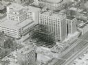
| Date: | 1958 |
|---|---|
| Description: | An aerial view of the contruction of a new wing on the State Office Building. |
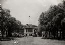
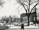
| Date: | 1954 |
|---|---|
| Description: | View of Bascom Hall from Bascom Hill (formerly Main Hall) on the University of Wisconsin-Madison campus. A few people are sitting on the lawn in front of ... |
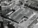
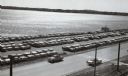
| Date: | 10 03 1958 |
|---|---|
| Description: | Law Park parking lot along Lake Monona. |
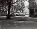
| Date: | 1955 |
|---|---|
| Description: | West Doty Street, from Monona Avenue looking toward South Carroll Street, showing the back side of Madison Newspapers, Inc. The building was added on to in... |

| Date: | 1957 |
|---|---|
| Description: | Aerial view of the north corner of Capitol Square looking toward Lake Mendota. The Belmont Hotel is featured prominently. |

| Date: | 12 23 1954 |
|---|---|
| Description: | Aerial view of the intersection of the West Beltline Highway and Verona Road (Highways 18-151). Includes Vikingtown Motel, town of Madison hall, Ballweg's ... |
| Date: | 10 03 1958 |
|---|---|
| Description: | The Law Park parking lot, on the shore of Lake Monona. |

| Date: | 1958 |
|---|---|
| Description: | An aerial view of the construction of a new wing on a state office building. Automobiles are parked in a log along Lake Monona. |
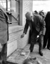
| Date: | 05 14 1950 |
|---|---|
| Description: | President Harry S. Truman visited Madison to be present at the laying of the cornerstone for the CUNA's Filene House, 1617 Sherman Avenue. He is pictured ... |

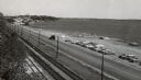
| Date: | 1957 |
|---|---|
| Description: | Law Park along Lake Monona, before filling in the shoreline to construct a road and parking lot. |

| Date: | 1955 |
|---|---|
| Description: | Aerial view of Atwood Avenue, looking west towards Winnebago Street and "Schenk's Corners." |
If you didn't find the material you searched for, our Library Reference Staff can help.
Call our reference desk at 608-264-6535 or email us at: