Search: Madison
Filter: Subject of aerial photographs
Search: Madison
Filter: Subject of aerial photographs
| Date: | 1979 |
|---|---|
| Description: | Text on reverse reads: "Madison, Wisconsin photographed on infrared film at an altitude of 22 miles from a NASA research aircraft. Red = vegetation Blue ... |
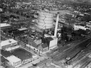
| Date: | 1924 |
|---|---|
| Description: | Aerial view of a Madison Gas and Electric steam plant. |

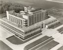
| Date: | |
|---|---|
| Description: | Aerial view of Madison General Hospital and surrounding neighborhood. |

| Date: | 1930 |
|---|---|
| Description: | Aerial view above Shorewood Hills near Madison, looking northeast. |

| Date: | |
|---|---|
| Description: | Aerial view looking southwest over the University of Wisconsin-Madison Stock Pavilion barns. |

| Date: | |
|---|---|
| Description: | Aerial view of Madison featuring Central High School/Madison Area Technical College (MATC) at top center. |

| Date: | 04 27 1951 |
|---|---|
| Description: | A composite map of the Madison area taken from aerial photos by Abrams Aerial Survey Corporation for the Madison Planning Commission. |

| Date: | |
|---|---|
| Description: | University of Wisconsin-Madison Agricultural buildings. The isthmus and Lake Mendota can also be seen. |

| Date: | 10 16 1962 |
|---|---|
| Description: | The intersection of Interstate Highway I-90 and USH 12/18 east of Madison. This view looks toward the southeast |
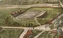
| Date: | 1908 |
|---|---|
| Description: | Colorized aerial view of Camp Randall Stadium at the University of Wisconsin-Madison. |
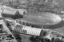
| Date: | 1956 |
|---|---|
| Description: | Aerial view of Camp Randall Stadium and Field House on the University of Wisconsin-Madison campus. |

| Date: | 1924 |
|---|---|
| Description: | Aerial view of Madison's Willow Beach towards the University of Wisconsin-Madison campus, downtown Madison, and Lake Monona. |
| Date: | |
|---|---|
| Description: | Aerial view of Madison, including Yost's, State Street, The Orpheum Theatre, Hills, the Madison Public Library, block 64 parking, East Johnson Street, and ... |
| Date: | 04 21 1948 |
|---|---|
| Description: | Aerial photograph of the west side of Madison and the western edge of Lake Mendota. Taken over the west side of Madison looking northwest toward Middleton. |

| Date: | 1946 |
|---|---|
| Description: | Aerial view of University of Wisconsin-Madison campus with Bascom Hill area, Observatory Drive and Lake Mendota. |

| Date: | 1930 |
|---|---|
| Description: | Aerial view of the University of Wisconsin-Madison Arboretum including the surrounding residential neighborhoods. |

| Date: | 10 17 1952 |
|---|---|
| Description: | Aerial view of Madison General Hospital and surrounding neighborhood. |

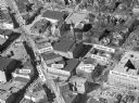
| Date: | 05 11 1951 |
|---|---|
| Description: | Aerial view of downtown Madison looking from State Street to King Street. |
If you didn't find the material you searched for, our Library Reference Staff can help.
Call our reference desk at 608-264-6535 or email us at: