Visit our other Wisconsin Historical Society websites!
 Search: Madison
Filter: Subject of lakes
Search: Madison
Filter: Subject of lakes

| Date: | 1978 |
|---|---|
| Description: | Bird’s-eye view map. Shows Madison from the edge of Lake Monona stretching west. Above the map are clouds and in the distance is the edge of the world and ... |

| Date: | 1855 |
|---|---|
| Description: | This map shows a plat of the city, local streets, numbered blocks and lots, university grounds, the Capitol Square, and parts of Third and Fourth Lakes (La... |

| Date: | |
|---|---|
| Description: | Text on back reads: The Madison skyline from across Lake Monona with the new Monona Terrace Convention Center. |
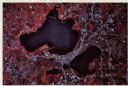
| Date: | 1979 |
|---|---|
| Description: | Text on reverse reads: "Madison, Wisconsin photographed on infrared film at an altitude of 22 miles from a NASA research aircraft. Red = vegetation Blue ... |
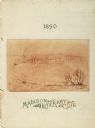
| Date: | 1890 |
|---|---|
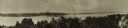
| Description: | Drawing depicting a distant view across water towards the city of Madison. |

| Date: | 1908 |
|---|---|
| Description: | Sanborn map of Madison, including West Gilman and Langdon Streets. |

| Date: | 1910 |
|---|---|
| Description: | Bird's-eye view. Caption reads: "Madison, Wis. and the Four Lake Region." |

| Date: | 1950 |
|---|---|
| Description: | Aerial view of the Madison isthmus looking north. Caption reads: "Madison Wisconsin — Between Lake Mendota and Lake Monona". |
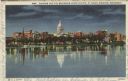
| Date: | 1940 |
|---|---|
| Description: | Twilight view of the Madison skyline across Lake Monona. Caption reads: "Madison and the Wisconsin State Capitol at Night, Madison, Wisconsin." |

| Date: | 1905 |
|---|---|
| Description: | View of Madison from across Lake Monona. A boat is moored near trees at the shoreline of the lake in the foreground. Caption reads: "Madison, Wis. Glimpse ... |
| Date: | |
|---|---|
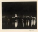
| Description: | Night view across Lake Monona towards downtown Madison. |

| Date: | 1930 |
|---|---|
| Description: | Lower left hand corner reads: "Compliment of the Madison Association of Commerce MADISON The Four Lake City WISCONSIN." Around the perimeter of the map is ... |

| Date: | 1930 |
|---|---|
| Description: | Aerial view above Shorewood Hills near Madison, looking northeast. |

| Date: | |
|---|---|
| Description: | Merrill Springs on Lake Mendota. Caption reads: "Madison Wis. The Old Merrill Spring." |

| Date: | 1902 |
|---|---|
| Description: | Madison Sanborn map, including Langdon and State Streets. |

| Date: | 1942 |
|---|---|
| Description: | A detail of a Madison Sanborn map, including Lakelawn Place. |
| Date: | |
|---|---|
| Description: | Panoramic view of the Madison skyline featuring the Wisconsin State Capitol. |

| Date: | 1890 |
|---|---|
| Description: | Portion of a plat map of Madison featuring Lake Mendota. |
If you didn't find the material you searched for, our Library Reference Staff can help.
Call our reference desk at 608-264-6535 or email us at:

