Search: Madison
Filter: Subject of rivers
Search: Madison
Filter: Subject of rivers

| Date: | 1930 |
|---|---|
| Description: | Lower left hand corner reads: "Compliment of the Madison Association of Commerce MADISON The Four Lake City WISCONSIN." Around the perimeter of the map is ... |

| Date: | 1890 |
|---|---|
| Description: | Left half of a plat map of the "East Part of the city of Madison". |

| Date: | |
|---|---|
| Description: | View of a bridge in Tenney Park surrounded by shrubs and trees. Caption reads: "Bridge in Tenney Park, Madison, Wis." |

| Date: | 1905 |
|---|---|
| Description: | View of the lagoon and surrounding wooded area in Tenney Park. Caption reads: "Lagoon in Tenney Park, Madison, Wis." |

| Date: | 1899 |
|---|---|
| Description: | A map of the east part of the city of Madison, including a portion of the isthmus. |

| Date: | 1911 |
|---|---|
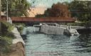
| Description: | Cascades of the Yahara River at Tenney Park. Caption reads: "The Cascades, Tenney Park, Madison, Wis." |

| Date: | 1908 |
|---|---|
| Description: | A Sanborn map of the isthmus, which includes the map key. |

| Date: | 1928 |
|---|---|
| Description: | Birds-eye view showing Lake Mendota, Lake Monona, Lake Wingra, Lake Waubesa and Lake Kegonsa. Shows the growth of Madison from the Isthmus along the southe... |

| Date: | 1853 |
|---|---|
| Description: | Farwell's Mill on the Yahara River at Lake Mendota. |

| Date: | 1910 |
|---|---|
| Description: | Scale: 1:62500. Topography by Robert Muldrow. Surveyed in 1904. Edition of Aug. 1906, reprinted in 1910. |

| Date: | 1910 |
|---|---|
| Description: | Map of Dane County rural delivery in Madison and the town of Westport. |
| Date: | 1910 |
|---|---|
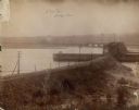
| Description: | View of the Sherman Bridge and Lock and surrounding area on the Yahara River. Caption reads: "Sherman Avenue Bridge and Locks, Yahara River, Madison, Wis." |

| Date: | 1909 |
|---|---|
| Description: | View of the lagoon at Tenney Park, surrounded by trees, with a bridge in the distance. Caption reads: "Lagoon and Bridge, Tenney Park, Madison, Wis." |

| Date: | 1908 |
|---|---|
| Description: | Bird's-eye view showing Lake Mendota, Lake Monona, Lake Waubesa, Lake Wingra and Lake Kegonsa. Madison has only the isthmus developed, and there are settle... |

| Date: | 1907 |
|---|---|
| Description: | Bridge and Lagoon in Tenney Park. Caption reads: "Bridge and Lagoon, Tenney Park, Madison, Wisconsin." |

| Date: | 1836 |
|---|---|
| Description: | The top map is the "Plat of Madison the Capitol of Wisconsin." The bottom map is the "Map of the Four Lake Country. Taken from the Township Maps in the U.S... |

| Date: | 12 16 1949 |
|---|---|
| Description: | Scene along the Yahara River where the body of Max Hobert, a Madison bartender, was found. |
If you didn't find the material you searched for, our Library Reference Staff can help.
Call our reference desk at 608-264-6535 or email us at: