 Search: State
Search: Street
Filter: County of Brown
Filter: Subject of water
Search: State
Search: Street
Filter: County of Brown
Filter: Subject of water
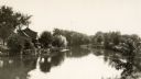
| Date: | 1920 |
|---|---|
| Description: | View of the East River seen from the east end of Pine Street. |

| Date: | 1850 |
|---|---|
| Description: | This photocopied map shows lot and block numbers, selected buildings, street names and state lock located on the Fox River. Includes a description of Deper... |
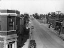
| Date: | 1930 |
|---|---|
| Description: | Elevated view of High Street (Highway 96) and the bridge over the Fox River at Wrightstown. Farmers & Traders Bank is at left, a sign for Meuleman's Elect... |

| Date: | 1963 |
|---|---|
| Description: | This blue line print shows as of March 1960 federal, state, county, and town roads, as well as railroads, schools, churches, town hall, parks, and Brown Co... |
If you didn't find the material you searched for, our Library Reference Staff can help.
Call our reference desk at 608-264-6535 or email us at: