 Search: Wisconsin
Search: Conservation
Search: Department
Filter: Subject of landforms
Search: Wisconsin
Search: Conservation
Search: Department
Filter: Subject of landforms

| Date: | 1935 |
|---|---|
| Description: | A sand dune in Point Beach State Forest has engulfed several trees. Two dead trees are standing in the foreground. |
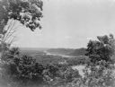
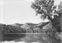
| Date: | 1935 |
|---|---|
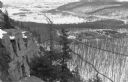
| Description: | Elevated view, looking north, from Mt. Hosmer, with tall bluffs on the far (Wisconsin) side of the Mississippi River. There are multiple sloughs and island... |
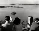
| Date: | 1945 |
|---|---|
| Description: | People on observation tower looking at Sturgeon Bay. |

| Date: | 1940 |
|---|---|
| Description: | The description on the reverse of this print describes the scene: "A horseback rider pauses to view the beauties of Devils Lake nestled among the bluffs at... |
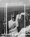
| Date: | 1950 |
|---|---|
| Description: | In this photograph marked for cropping for publication, a group including a young woman, two young men and a boy observe the features of a rock outcropping... |
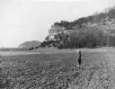
| Date: | 1950 |
|---|---|
| Description: | A young girl wearing a winter coat and hat is standing in a tilled field at the base of Cassell, or Leykauf, Bluff. A description on the reverse of the pri... |
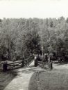
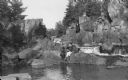
| Date: | |
|---|---|
| Description: | Two people on a rustic bridge over Bad River at Copper Falls State Park. |
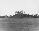
| Date: | |
|---|---|
| Description: | View across a field toward a kame, a cone-shaped hill formed by water pouring down through a hole in a melting glacier. |

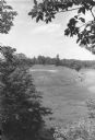
| Date: | |
|---|---|
| Description: | Elevated view of the park and the Lake Michigan shoreline. Description on the photograph record reads: "Looking Northeast from Sven's Tower." |
| Date: | 1935 |
|---|---|
| Description: | Four bluffs are reflected in the back waters of the Mississippi River. A large tree on the right frames the view. |

| Date: | 1935 |
|---|---|
| Description: | Elevated panoramic view of the Wisconsin River looking north from Tower Hill State Park. There are sandbars in the river. The water tower and village of Sp... |
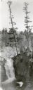
| Date: | 1930 |
|---|---|
| Description: | An elevated view of Brownstone Falls. Two tall pines are growing at the top edge of a rock to the right of the falls. |
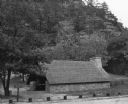
| Date: | 1938 |
|---|---|
| Description: | The picnic shelter at the east picnic area in Mill Bluff State Park is sitting at the base of a large rock outcropping. The shelter has low stone walls and... |

| Date: | 1935 |
|---|---|
| Description: | Slightly elevated view of the Eau Claire River flowing between block-like rock formations downstream from a stone bridge in the Dells of the Eau Claire Cou... |
| Date: | 1939 |
|---|---|
| Description: | An elevated view of a sharp curve of an esker in the Northern Unit of the Kettle Moraine State Forest. |

| Date: | 1950 |
|---|---|
| Description: | Castle Rock, surrounded by trees and a meadow. The geological feature is near Volk Field Air National Guard Base. |

| Date: | 1940 |
|---|---|
| Description: | A view from the top of Gibraltar Rock showing a portion of the bluff, left, and rolling fields and woodlands beyond. There is a pond or stream on the right... |
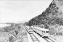
| Date: | 1935 |
|---|---|
| Description: | Two streamlined style, stainless steel clad passenger trains meet on the tracks at the base of a bluff along the Mississippi River near La Crosse. A sign ... |
| Date: | 1937 |
|---|---|
| Description: | View across water towards an unidentified man and woman sitting on rocks at the edge of the Pike River, with Dave's Falls behind them. |
| Date: | 1935 |
|---|---|
| Description: | Elevated view, from the South Bluff, of the CCC camp at Devil's Lake State Park. There is a rock outcropping in the foreground on the left. South Shore Roa... |
If you didn't find the material you searched for, our Library Reference Staff can help.
Call our reference desk at 608-264-6535 or email us at: