Search: Wisconsin
Search: Conservation
Search: Department
Filter: Subject of rivers
Search: Wisconsin
Search: Conservation
Search: Department
Filter: Subject of rivers
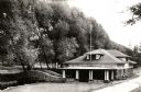
| Date: | 1935 |
|---|---|
| Description: | Wisconsin Conservation Department fish hatchery near Woodruff. |

| Date: | 1937 |
|---|---|
| Description: | This Wisconsin Conservation Department map shows the locations of state forests, national forests, county forests, state nurseries, Indian reservations, st... |

| Date: | 1937 |
|---|---|
| Description: | This map shows the Wisconsin Conservation Department forest protection divisions and the locations of state forests, national forests, Indian reservations,... |

| Date: | 05 01 1938 |
|---|---|
| Description: | This map shows the locations of Wisconsin Conservation Department forest protection districts and cooperative areas, state forests, national forests, India... |

| Date: | 1936 |
|---|---|
| Description: | This 1936 Wisconsin Conservation Dept. map shows the locations of state forestry Civilian Conservation Corps (CCC) camps, closed state forestry CCC camps, ... |

| Date: | 1937 |
|---|---|
| Description: | This Wisconsin Conservation Department map shows the locations of game refuges, fish hatcheries, canning factories, fish camps, and fish refuges in the sta... |

| Date: | 1942 |
|---|---|
| Description: | Warden Kramer and his assistant in a boat removing an illegal snag line from the Wolf River. |

| Date: | 1952 |
|---|---|
| Description: | This Wisconsin Conservation Dept. map shows sections, roads, rivers, and lakes in the Town of Cloverland, Vilas County, Wisconsin as of February, 1952. It ... |
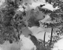
| Date: | 1950 |
|---|---|
| Description: | Snow and ice cover the upper portion of Copper Falls. There is also open water in the Bad River downstream from the falls. |

| Date: | 1952 |
|---|---|
| Description: | This Wisconsin Conservation Dept. map shows sections, roads, rivers, and lakes in the Town of Presque Isle, Vilas County, Wisconsin as of March 1953. It do... |

| Date: | 1937 |
|---|---|
| Description: | "Prepared ... March 1937." Includes location map. "State of Wisconsin, Conservation Department, Map Division"--upper left. From the E.P. Sherry papers rela... |
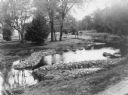
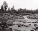
| Date: | 1935 |
|---|---|
| Description: | A stone weir has been built on a meandering river to improve it for fish habitat. |
| Date: | |
|---|---|
| Description: | Elevated view of Copper Falls on the Bad River. Four people, one man and three women, are posing on rocks at the top of the falls. Surrounding burned-over ... |

| Date: | 1940 |
|---|---|
| Description: | An unidentified man and woman are paddling their canoe against the current in the fast running Flambeau River. A small stand of leafless trees and blackene... |
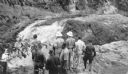
| Date: | 08 1940 |
|---|---|
| Description: | Elevated view of a group of Georgia Junior Rangers and their guides viewing the Copper Falls of the Bad River. |
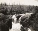
| Date: | 1935 |
|---|---|
| Description: | Elevated view of the Brownstone Falls on the Bad River. |

| Date: | 1933 |
|---|---|
| Description: | This 1933 Wisconsin Conservation Dept. map shows roads, railroads, trails, lakes and streams, and the Trout Lake Game Refuge in Northern State Forest (whic... |

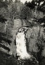
| Date: | |
|---|---|
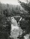
| Description: | View through trees of Copper Falls, on the Bad River. |
If you didn't find the material you searched for, our Library Reference Staff can help.
Call our reference desk at 608-264-6535 or email us at: