Search: Wisconsin
Search: Department
Filter: Creator Name of Wisconsin. Conservation Department.
Search: Wisconsin
Search: Department
Filter: Creator Name of Wisconsin. Conservation Department.

| Date: | 06 1934 |
|---|---|
| Description: | This Wisconsin Conservation Department map shows national, state, and county forests both approved and pending, as well as Indian reservations in Wisconsin... |

| Date: | 04 1932 |
|---|---|
| Description: | This Wisconsin Conservation Department map shows federal, state, and county forest areas, the relative proportion of land owned by each agency, and state p... |

| Date: | 05 1935 |
|---|---|
| Description: | This Wisconsin Conservation Department map shows the locations of state forests, state nurseries, state parks, roadside parks, prison camps, and lookout to... |

| Date: | 1946 |
|---|---|
| Description: | View of the Wisconsin State Capitol building and the surrounding area from Lake Monona. |

| Date: | 1937 |
|---|---|
| Description: | This map shows the Wisconsin Conservation Department forest protection divisions and the locations of state forests, national forests, Indian reservations,... |
| Date: | 04 1939 |
|---|---|
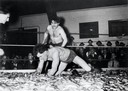
| Description: | Two men smelt wrestling at the Smelt Carnival in Marinette. |

| Date: | 05 01 1938 |
|---|---|
| Description: | This map shows the locations of Wisconsin Conservation Department forest protection districts and cooperative areas, state forests, national forests, India... |

| Date: | 1935 |
|---|---|
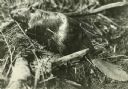
| Description: | Two eight point bucks are standing in dappled shade at the edge of a wooded area. |
| Date: | 1940 |
|---|---|
| Description: | Exterior view of the west wing of the Wisconsin State Capitol. |
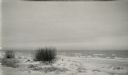
| Date: | |
|---|---|
| Description: | White sand and breaking waves along the beach at Terry Andrae State Park. |

| Date: | 1937 |
|---|---|
| Description: | This Wisconsin Conservation Department map shows the locations of state forests, national forests, county forests, state nurseries, Indian reservations, st... |

| Date: | 09 25 1937 |
|---|---|
| Description: | Governor Philip La Follette (Wisconsin) and Governor Henry Horner (Illinois) enjoy a laugh in the boat during a fishing trip. |

| Date: | 1940 |
|---|---|
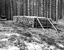
| Description: | A display by the Wisconsin Conservation Department erected in a large tent extols the value of smoking fish for food. There are posters identifying differe... |
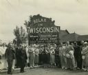
| Date: | |
|---|---|
| Description: | Group of resort and hotel owners gathered in front of a Wisconsin tourism sign that reads: "Relax In Wisconsin." There is a building in the background. |

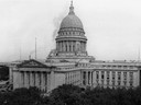
| Date: | 1944 |
|---|---|
| Description: | Elevated exterior view of the fourth Wisconsin State Capitol. |

| Date: | 1937 |
|---|---|
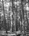
| Description: | Picnic and play area at Interstate Park, near the St. Croix River. Two girls swing as an adult male sits on a picnic table in the foreground with a child o... |

| Date: | 1937 |
|---|---|
| Description: | This Wisconsin Conservation Department map shows the locations of game refuges, fish hatcheries, canning factories, fish camps, and fish refuges in the sta... |
If you didn't find the material you searched for, our Library Reference Staff can help.
Call our reference desk at 608-264-6535 or email us at: