 Search: World
Search: War
Search: 1918
Filter: Categories of Wisconsin Historical Images
Filter: Type of Map or Atlas
Search: World
Search: War
Search: 1918
Filter: Categories of Wisconsin Historical Images
Filter: Type of Map or Atlas
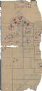
| Date: | 1918 |
|---|---|
| Description: | This World War I era map fragment depicting the western portion of Douglas County, Wisconsin, includes manuscript annotations and stickers pasted onto the ... |
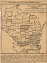
| Date: | 1918 |
|---|---|
| Description: | Removed from the "New York Sun," March 21, 1918. Shows "where disloyalty in Wisconsin chiefly centres." Shaded areas indicate regions of suspected pro-Germ... |
If you didn't find the material you searched for, our Library Reference Staff can help.
Call our reference desk at 608-264-6535 or email us at: